Click on graphic above to navigate the 165+ web files on this website, a regularly updated Gazetteer, an in-depth description of our island's internally self-governing British Overseas Territory 900 miles north of the Caribbean, 600 miles east of North Carolina, USA. With accommodation options, airlines, airport, actors, actresses, aviation, banks, beaches, Bermuda Dollar, Bermuda Government, Bermuda-incorporated businesses and companies including insurers and reinsurers, Bermudians, books and publications, bridges and causeway, charities, churches, citizenship by Status, City of Hamilton, commerce, communities, credit cards, cruise ships, cuisine, currency, disability accessibility, Devonshire Parish, districts, Dockyard, economy, education, employers, employment, environment, executorships, fauna, ferries, flora, former military bases, forts, gardens, geography, getting around, golf, guest houses, highways, history, historic properties, Hamilton, House of Assembly, housing, hotels, immigration, import duties, internet access, islands, laws, legal system and legislators, main roads, marriages, media, members of parliament, money, motor vehicles, municipalities, music and musicians, newcomers, newspaper, media, organizations, parks, parishes, Paget, Pembroke, performing artists, residents, pensions, political parties, postage stamps, public holidays, public transportation, railway trail, real estate, registries of aircraft and ships, religions, Royal Naval Dockyard, Sandys, senior citizens, Smith's, Somerset Village, Southampton, St. David's Island, St George's, Spanish Point, Spittal Pond, sports, taxes, telecommunications, time zone, traditions, tourism, Town of St. George, Tucker's Town, utilities, water sports, Warwick, weather, wildlife, work permits.

![]()
By Keith Archibald Forbes (see About Us).

Part of Crest of St. George's Parish, from that of Admiral Sir George Somers. His Somers coat of arms, copyrighted by his family, members of which still exist today, is exactly what is shown on Bermuda's St. George's Parish crest. Used with exclusive permission from the copyright owners. Do not copy.
 St.
George's Parish was named for Bermuda's Elizabethan patron and founder, Englishman
Admiral Sir George Somers.
Places in the United Kingdom dedicated to his saintly name and history
include St. George's, Vale of Glamorgan, Wales; St. George's Island,
Cornwall, England and Ogbourne St. George, in Wiltshire, England. Other
places include the nearby Town
of St. George in Bermuda , of course, usually referred to as St.
George's and in this Parish; Georgetown in the Cayman Islands, Georgetown
of Guyana in South America and St. George's of Grenada in the Caribbean.
St.
George's Parish was named for Bermuda's Elizabethan patron and founder, Englishman
Admiral Sir George Somers.
Places in the United Kingdom dedicated to his saintly name and history
include St. George's, Vale of Glamorgan, Wales; St. George's Island,
Cornwall, England and Ogbourne St. George, in Wiltshire, England. Other
places include the nearby Town
of St. George in Bermuda , of course, usually referred to as St.
George's and in this Parish; Georgetown in the Cayman Islands, Georgetown
of Guyana in South America and St. George's of Grenada in the Caribbean.
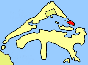
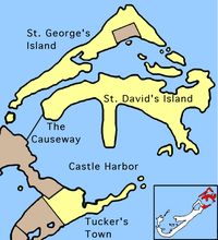
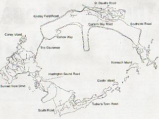
St. George's Parish is all of St. George's Island (originally known as Tortus Island) and partly Main Island, Bermuda's biggest island and historically significant. St. George's Island is 703 acres.
St. George's Island - then referred to as King's Island because it was where the British King's representative was based - was the first to be colonized. It includes St. George's Harbor, all of St. David's Island, originally 503 acres but enlarged in 1942 to over 650 acres build the (now decommissioned) Fort Bell (US Army), then Kindley Air Force Base (USAF), then USNAS.
The Parish starts where Hamilton Parish ends, on the road after Blue Hole Hill, before the Causeway to the airport. It is joined to Main via a road and to St. George's Island via the Swing Bridge, then over it and Longbird bridges briefly into Hamilton Parish then this Parish again at Tucker's Town and Castle Islands..
The Parish also includes all islands in St. George's Harbor; the Causeway; Coney Island and Ferry Island. (It once provided the horse ferry as the only connection between St. George's Island and Main Island.
Bermuda's Architectural Heritage: St. George's. Jarvis, Michael, edited by White, David L. Photos by Robin Judah and sidebars by Trimingham, Andrew. November, 1997. Bermuda National Trust. Second in the series.
![]()
 Constituencies in the Bermuda
Parliament
Constituencies in the Bermuda
Parliament Map to the right shows all the areas covered by these four constituencies. Note how Castle Harbour is in the centre. The Causeway is the bridge over Castle Harbour that links all four constituencies.
Map below shows layout of the Parish in greater detail.
But not the physical boundary of the Town of St. George in the Parish. Which is why we have a separate website for the town. The bus route does not go as far as Fort St. Catherine, which in the Parish but not the Town.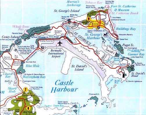
![]()
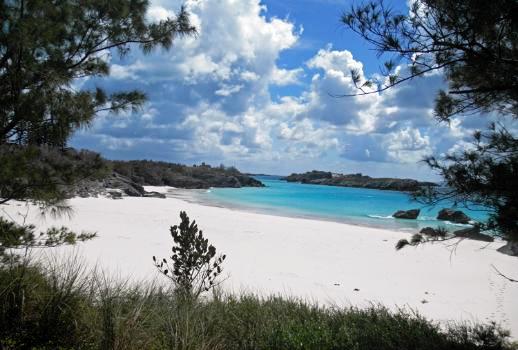
Achilles Bay. Cut Road, St. George's, northeast of the town of St. George. Private, for guests of the St. George's Club. Nice, but not on a bus route. Close to St George's Town, Fort St. Catherine, restaurant and golf club. Picturesque, small, soft sand more white than pink, usually with calm, shallow blue waters rocky in places, not crowded. Good for snorkeling. A Bermuda National Park. Named as such by middle of the 18th century and shown on a map dated 1757. It is not known exactly why it is so named, but probably by a local legislator and definitely had nothing to do with the mythical Greek hero in Homer's Iliad. Beach towels, lounge chairs and umbrellas are available on this private beach. Scenes of land, sea and the ramparts of Fort St. Catherine are stupendous.
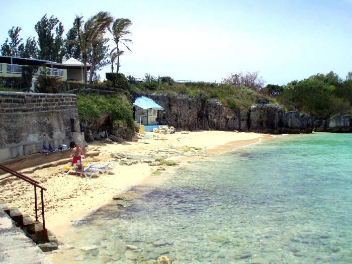
Achilles Bay beach
![]()
An eastern fort. A cannon-shot from Gate's Fort or Fort St. Catherine, it was erected on the site of Buildings Bay Battery, a work probably of the 1840s of which little is known. It is named after a Princess of Denmark, the then young wife of Edward, a son of Queen Victoria and Prince Albert, later to be Edward VII, King of Great Britain and Emperor of India. Alexandra Caroline Marie Charlotte Louise Julia was the daughter of King Christian IX of Denmark and married Edward at the age of 17 in March 1863.

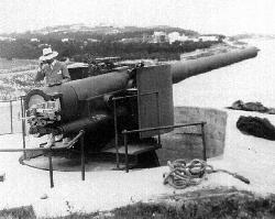
Left: Princess Alexandra, after whom the fortification was named.
The Princess's battery was built originally and specifically for a new type of gun, the Rifled Muzzle Loader, of which one is at the site, and its gun ports were unique in Bermuda, being made in wrought iron in the "Gibraltar Shield" pattern. At the beginning of the 1900s, when Alexandra became the Queen consort, the battery was modernized and armed with two 6-inch Rifled Breech Loaders, then with an upgrade to the latest type of weaponry for coastal fortifications. It was last manned as a gun battery in World Wars 1 and 2.
During her long marriage to the Prince of Wales and later king, Alexandra put up with Edward's continued association with other women. Alexandra was immensely popular with the population of Britain at large right into 1925, the year of her death.
This battery had a new lease of life in 1998, with its interior once again opened to the public.
![]()
St Georges. One of two dairy farms supplying local milk to Dunkleys Dairy. The other, Green Land Dairy Farm, with its 100-plus herd of cattle, is in Smith's Parish. It is now owned by Almeida Dairy Farm. Paul Almeida, the owner of Almeida Farm, said: I always wanted to be a bigger farm. We now have more than 150 cows. Green Land was the largest and I was the second-largest.
![]()
 Ferry
Reach. A private property, still
unofficially referred to as the Astor Estate although it has not been owned for decades by the
one-famous Astor family. It got its name from American tycoon Vincent Astor (1891-1959). He was son of John Astor who died on the
Titanic). Vincent Astor built an estate here, on the South Shore of Ferry Reach, at great
expense in the late1930's. Earlier, Astor was
the major benefactor of the Bermuda Aquarium from 1926 and arranged most of the financing
when it was at Agar's Island.
Ferry
Reach. A private property, still
unofficially referred to as the Astor Estate although it has not been owned for decades by the
one-famous Astor family. It got its name from American tycoon Vincent Astor (1891-1959). He was son of John Astor who died on the
Titanic). Vincent Astor built an estate here, on the South Shore of Ferry Reach, at great
expense in the late1930's. Earlier, Astor was
the major benefactor of the Bermuda Aquarium from 1926 and arranged most of the financing
when it was at Agar's Island.
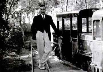
In 1938, to repeat the success to him and his family of the private railway system he had built on his estate in the USA, Astor also created on his Bermuda property a 2ft gauge (narrow gauge) railway train, a Baldwin Baltimore & Ohio Mainliner 2-6-2 with an initial 800 feet (later, another 600 feet) of his own track with 2 small purpose-built passenger carriages each seating four people and two luggage cars, run by the made-in-the-USA Baldwin locomotive and matching carriages - which carried him and his guests over the hill to his own private station - referred to as Astor's Siding - on the Bermuda Railway. The train, named the Ferry Reach" ran through the Ferry Road tunnel after exiting the main line at Ferry Reach and into the gardens of Astor's Ferry Reach House.
Photo right: Vincent Astor and his Bermuda train
Astor's Siding was built to allow Astor's passengers to transfer to the Bermuda system and his arrangement worked well while (a) he maintained a residence there. The couple divorced in 1939/940. (Helen became Mrs. Lytle Hall later that year). As the Second World War became more complex Vincent's involvement, including with the US Navy, took him increasingly away from the house in Bermuda.
The Bermuda Railway system operated until 1948 when everything - engines, carriages, other rolling stock and equipment were sold to the Bermuda Government which resold and transported it to British Guiana, later Guyana).
The property includes a sprawling mansion and guest cottages, all still there, and a large boat house. Approachable from the southern side, not the former Bermuda Railway northern side. This area of the Parish is known as Ferry Reach from the fact that ferries once plied these waters. The property which long ago passed into private local hands (believed to one point to have been Herbie Bierman who died in 1971 but the Bierman family is still the dominant one in the sale of Bermuda-made concrete) has since been subdivided into apartments or cottages.
New Yorker Decorative arts historian, author and lecturer, Derek Ostergard believes the architects for the house selected by Astor's first wife Helen Huntington Astor were N. W Hutchings and J. F. Hutchings, brothers, of Bermuda. They would have been familiar with indigenous building materials, permits, etc. in ways unknown to architects not living in Bermuda. Mr. Ostergard related how the interiors of the Bermuda Astor house were arranged by Anne Cameron Tiffany - a then-noted, but now barely remembered American society decorator. Mr. Ostergard believes Helen Astor (nee Helen Dinsmore Huntington) personally researched the indigenous architecture of Bermuda which she greatly admired and had them integrated into the massive structure of this house. Vincent and Helen were wed on April 30, 1914. It is said that at the ceremony, he was stricken with the mumps.
The remains of what looks like one carriage and the engine was photographed by this author in 2003 (see photographs below), clearly in an appalling condition, rusted out for decades. Beyond his property, Astor rented use of the railway track from the Bermuda railway operators to run his private guests to other parts of the island on periodic sightseeing trips, at times that did not conflict with those of the railway system. Some effort was begun in 1967 by then-owner Herbert Bierman in hopes of engine and carriage restoration but when he died in 1970 all work stopped and was not later resumed.
Interestingly, at about the same time as the Astor railway was built, there was a similar-gauge small railway in the United Kingdom, the Lynton & Barnstaple Railway (L&BR) - now a Trust in the UK, with a similar or identical Baldwin locomotive, which was scrapped back in 1935. L&BR was restored in 1979 and now runs a steam service.
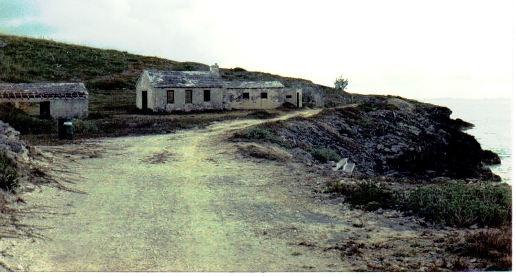
Old Private Ferry Reach Station for the Astor family with Astor building nearby. Photo by this website's author Keith A Forbes.
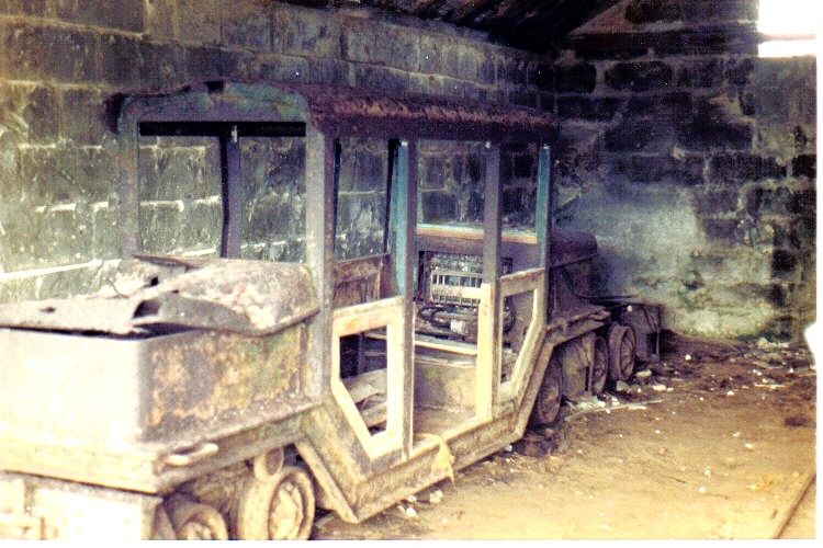
Equipment in building next to the Astor Ferry Reach station. Photo by this website's author Keith A Forbes.
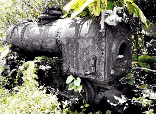
Remains of old Baldwin steam engine. Photo by this website's author Keith A Forbes.
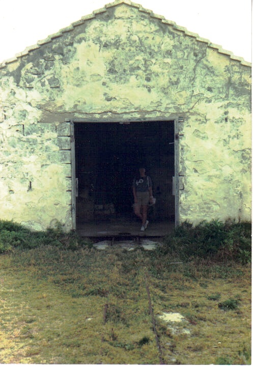
Another view of old building for Astor private railway. Photos by author Keith A. Forbes exclusively for and copyrighted by Bermuda Online
Today, these rust-ridden relics are the only rolling-stock remnants anywhere in Bermuda of both the original Astor Estate railway and the Bermuda Railway. It may be too late now to have them restored as unique pieces of Bermuda railway history. At this time it is not known for sure whether Astor still owned the property when he died or whether it was after he died that the estate was sold to others.
In 1941 the-then pristine Castle Harbour to the south (one of the two main sea vistas of the house, with the other having equally unobstructed sweeping views of the Atlantic Ocean to the north and small beaches nearby), was substantially altered from 1941 by the destruction of a number of small islands opposite them at massive American taxpayer expense to make what become the new (1941 to 1995) American military base on St. David's Island first known as Fort Bell of the US Army, then a United States Army Air Force, then US Air Force base and today Kindley Field, (now part of the Bermuda international airport).
In 1962, an RB-47 reconnaissance aircraft from the United States Air Force crashed on the property after taking off from the nearby Kindley Air Force Base and damaged some of the outbuildings. All four crew members perished.
![]()
 Until
its change of name in 2006 known as the Bermuda Biological Station for Research
(BBSR).
Until
its change of name in 2006 known as the Bermuda Biological Station for Research
(BBSR).
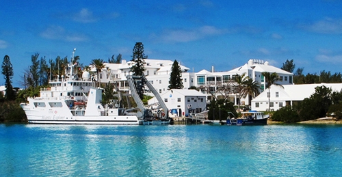
Telephone (441) 297-1880. One mile before the Town of St. George boundary and just across from the airport. On a Wednesday, there is a free guided tour starting at about 10 am. Buses will drop you off a half mile away, or you can park a moped. Areas of specialization include marine biology, mariculture, monitoring of global environmental dangers and global warming signs, oceanography and studies of the Gulf Stream. Founded in 1903 by scientists from Harvard University, New York University and the Bermuda Natural History Society as a station for research in biology and zoology. Incorporated in New York in 1926 as a US not-for-profit organisation. By 1932 the Bermuda Government and the Rockefeller Foundation joined forces to provide facilities and a modest endowment, and opened the BBSR at its present location in Ferry Reach, St. George's. The scope and focus of the organisation has grown and the new name has been devised to reflect its current status as a world-class science and educational institute focusing on marine ecosystems, ocean/atmospheric interactions and ocean health, as well as their influence on man's habitat and health.
One a local hotel and later a field hospital for the US Army in the early 1940s, it conducts high quality research from a mid ocean island; educates future scientists; and provides well equipped facilities and technical staff support for visiting scientists, faculty and students. A bonus has been the number of local students who have participated in special courses at the facility and then gone on to become scientists. One of its projects is the Risk Prediction Initiative. It carries out large scale predictions by correlating data from the scientific community on oceans and atmosphere. The intention is to better understand the implications of things like hurricanes, floods, droughts, and so on. The impact of these on all communities affected and on business is profound. Thus, the-then Biological Station has joined forces with the reinsurance industry in Bermuda and world-wide, working on the prediction of natural phenomena and in bringing both science and business together to do so.
The work carried out in the Bermuda Atlantic Time Series Study (BATS) is the longest continuous experiment of its kind. There has been a unique opportunity to monitor global changes by comparing what has happened in the past - water levels, ocean and atmospheric interchange, the "greenhouse" effect, to show how world environment is more affected by the atmosphere and the oceans than by anything else. Scientists are also involved in ongoing projects relating to the effect of oil spills in oceans, with emphasis on particularly fragile areas such as coral reefs and mangroves; and in the molecular field, with biologists looking at potential medicinal benefits from the oceans. For example, experiments on Bermuda sponges have led to the possibility that certain compounds can be utilized as drugs to treat illnesses such as cancer and arthritis.
In July 2004, the Bermuda Biological Station was awarded a Bermuda Government Environmental Grant Scheme to support a research project into the health and ecology of sea grass beds around Bermuda, the causes of their decline and the potential for remediation.
![]()
![]()
Listed separately by name below.
![]()
![]()
![]()
See under St. George's Military Cemeteries shown below
Also see Ferry Point and Ferry Reach Cemeteries shown below.
![]()
![]()
The society there is a museum of Bermudian history.
![]()
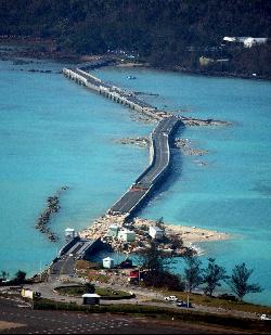 The Causeway
itself is not merely a bridge as often assumed by visitors. It spans Castle Harbor as a series of flat and
arch spans. It is the
narrow, man-made strip of land linking Hamilton Parish with St. George's Parish. It was first
built in 1864 by the Bermuda Government, rebuilt
in 1871 after the first hurricane and originally
stretched from Blue Hole Hill to and through Long Bird Island. It is the only
link between St. George's, the Airport and the rest of the Island. .
The Causeway
itself is not merely a bridge as often assumed by visitors. It spans Castle Harbor as a series of flat and
arch spans. It is the
narrow, man-made strip of land linking Hamilton Parish with St. George's Parish. It was first
built in 1864 by the Bermuda Government, rebuilt
in 1871 after the first hurricane and originally
stretched from Blue Hole Hill to and through Long Bird Island. It is the only
link between St. George's, the Airport and the rest of the Island. .
At one point it linked up with the old Swing Bridge to St. Georges. When construction began at the US military base Kindley in 1941, part of Long Bird Island was demolished, and the passageway between the islands filled with dredged material to create the airfield. It has been rebuilt several times again because of hurricane damage.
Longbird Bridge is at the airport end of the causeway and is so-called because it was part of Longbird Island until 1942. Where the nearby airport and adjacent area is now was was once a line of islands, Jones', 2.5 acres; Little Round, Long Cay, Round and Sandy.
Long Bird Island, once 62 acres, was the biggest of these islands. This bridge, the smaller of two swing bridges in the area, is a two-span steel girder with an open grating traffic deck.
In its closed position, it lets traffic pass over it and is supported at the east and west abutments and at the pivot pier immediately under the control house. When the bridge is opened to allow the passage of boats, all road traffic stops on either side of the bridge and the east and west supports are withdrawn. In this position, the bridge becomes a balanced cantilever supported only on roller wheels on the pivot pier. It can then be rotated by hydraulic rams to its open position.
In this condition, balance is provided by a concrete counterweight on the bobtail span and the bridge cannot carry traffic.
2019. June 19. The Government asked organisations to show how they could help fund the replacement of Longbird Bridge and Swing Bridges according to documents published on its website. A request for information issued through the Ministry of Public Works also appealed for fabricators, project managers and suppliers from around the world to express interest in the projects, as the existing structures in St Georges were both expected to reach the end of their useful lives in 2021. It said detailed designs for the bridges were almost complete and a package of drawings for tenders was scheduled to be published this year. A separate request for proposals invited bids from contractors to demolish and remove Longbird Bridge, which has been closed to traffic for more than a decade. The public RFI for the replacement project was issued on June 7 and an accompanying document, titled Moving Bermuda Forward, explained: The Ministry of Public Works, Government of Bermuda, intends to replace two of their main access bridges. The new bridges will be structural landmarks to be used by locals and visitors for years to come. The ministry is looking to partner with international experts to work on these interesting projects. After the successful completion of an options study and a feasibility study, the design team has now entered into the detailed design phase. This design phase will result in a tender drawing set scheduled to be made public in the third quarter of 2019. The Ministry of Public Works is looking forward to bringing new members to the construction team to finance, fabricate and build these bridges. Interested companies were also told that limited resources meant most construction materials were imported to the island. The document added: The local labour is relatively expensive and specialization in bridge construction and complex infrastructure is limited. Hence, the ministry believes that high-level prefabrication will enable this project to achieve an economical solution and help reduce construction risk. The RFI, which was posted on the procurement notices page of the Governments website, said that the ministry wanted to gather information about the marketplace to help determine future purchasing options or requirements.
It explained that the ministry sought new members to supplement the design team in regard to financing, fabricating and building two new bridges. The document invited expressions of interest from disciplines including general and professional contractors, bridge or steelwork fabricators, financiers, project management, independent checkers, trades and suppliers. It was announced in December 2017 that three UK companies, Ramboll, the lead consultant, as well as Knight Architects and Eadon Consultants, would work together on the bridge replacements. Blueprints for the structures were unveiled last September when it was thought construction on the crossings would begin this summer. It was estimated then that the Longbird Bridge on to St Davids Island from the Causeway and The Main, the largest island in the Bermuda archipelago, would take two years to complete. Construction time for the Swing Bridge from St Davids to St Georges Island was expected to be 30 months. The separate RFP for the demolition of Longbird Bridge was issued on June 10 and has a submission deadline of 3pm on July 19, 2019. It said the public works ministry was inviting tenders from experienced contracting companies for the demolition, removal and safe disposal of the Longbird Bridge superstructure, piers, approach slabs, walls and services. The RFP explained that the present structure was built by the US Army Corps of Engineers and was officially opened in December 1952. When the US Naval Air Station left Bermuda in 1995, they handed over maintenance responsibility to Nasa, who left Bermuda in 1998 and abdicated responsibility. The Government of Bermudas requests for urgent maintenance went unanswered, and the Government assumed responsibility for the bridge, by default ,in December 1998. Rehabilitation works were completed in 2001, but by 2007 the bridge had once again fallen into disrepair. In May 2007, the bridge was closed to marine traffic, and vehicular traffic was reduced to one lane. On July 31, 2007, the bridge was permanently closed, with vehicles diverted to the two newly constructed panel bridges which are still in use today.
2018. September 28. Two new bridges being designed for the East End will be able to withstand Bermudas challenging climate including hurricane conditions and high humidity, designers said.
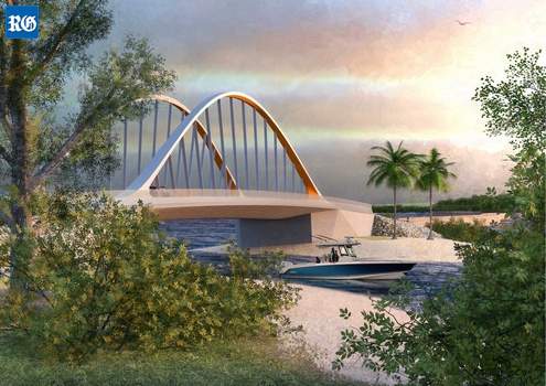
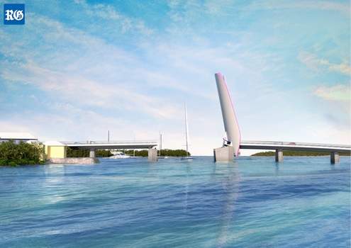
Longbird Bridge and Swing Bridge computer images supplied
The blueprints for the landmark structures, replacing the Swing Bridge and Longbird Bridge in St Georges, were presented to the public at an information session at Pennos Wharf on Wednesday evening. Steve Thompson, director of major crossings at Ramboll, the lead design consultant on the project, said that the new state-of-the-art Swing Bridge would need to be lowered and locked down during a hurricane, but could remain open for traffic depending on wind speeds. Speaking of the swing section that will lift up every 30 minutes to allow large marine vessels to pass, Mr Thompson told the packed audience: Wind loading is extremely important. We have done initial studies that indicate that the structure is stable during even hurricane winds. We dont have any concerns at the moment but it is something that will be studied in more detail. Both bridges will be built to last avoiding elements such as sharp edges which can easily rust and incorporating curves designed for free flow of water. Ricardo Graham-Ward, bridge engineer for the Ministry of Public Works, added: The new designs also must accommodate for rising storm surge in the future. These two important links to the East End will include adjoining walkways for pedestrians. If enough money is left over at the end of the project, the walkway could be extended to run alongside the Causeway, a feature one member of the audience said locals had wanted for years. Construction on the crossings is expected to begin next summer. It is estimated that the Longbird Bridge will take two years to complete and the Swing Bridge 30 months. Disruption to traffic in both incidences will be minimal during the construction phases. The temporary bridges alongside the Longbird Bridge will be kept open and the old Swing Bridge will remain operational until the new bridge is fully operational. The new bridge will take four minutes to raise and two minutes to lower, the same as the current bridge. Mr Graham-Ward said the Swing Bridge will be operated and maintained locally creating jobs and can function manually when maintenance works are in progress. He said that both bridges will be wider to improve road safety and will have increased clearance for marine vessels. One member of the public asked whether the Longbird Bridge could have extra clearance to allow vessels such as Fisheries and emergency boats to pass under. The presenters said they would look into it. The two structures are designed to mirror each other and take cues from Bermudas natural environment. The Swing Bridge is inspired by the eagle ray while the design of the Longbird Bridge is inspired by a combination of seashells and sea turtles. Mr Graham-Ward said: We want this bridge to be a spectacle, we want this to be an attraction, almost like a destination. Because of the proximity to the airport these are the first two main structures tourists will see and the last thing they see when they leave. It is important to entice them to come back and think not only is Bermudas environment beautiful but so are its landmarks. It is a great opportunity to create an identity. The potential costs of the bridge were not discussed. When asked by The Royal Gazette, Minister of Public Works Lieutenant-Colonel David Burch said he had learnt not to give cost estimates too early in a project. He said: It will come back to haunt you. Were not prepared to do that until we have the detailed designs for the bridge and know what materials we are going to use. At the end of phase three we will have a figure of what it will cost that will be driven, like everything that you build, by when you pull the trigger. If you wait, the number will only go in one direction. Mr Graham-Ward invited school groups get involved in the project. He said: I read in the newspaper that the schools are trying to implement a STEM curriculum. I am sure that this bridge project can be implemented into that curriculum either by hands on approach or by having students come on for site visits during the construction phases. The public were encouraged to offer input or voice concerns about the plans by contacting the Ministry of Public Works.
2018. September 25. New designs for Longbird and Swing Bridges will be unveiled tomorrow. The Ministry of Public Works described the designs as unique landmark structures which will reflect Bermudas welcoming culture. They will on display at an information session at Pennos Wharf, St Georges, from 6pm. British firm Ramboll is being paid $400,000 to design the replacements for the two bridges which are both expected to reach the end of their useful life in 2021. Swing Bridge, linking St Davids to St Georges, was built in the 1960s and has fallen into disrepair in recent years. The bridge no longer opens for passing boats. Longbird Bridge, a 60-metre twin-carriageway bridge at the eastern end of the Causeway, was built in the 1950s. It closed to traffic ten years ago when it was bypassed with twin Bailey bridges.
2017. December 8. British firm Ramboll will be paid $400,000 to design the replacements for Longbird Bridge and Swing Bridge, Lieutenant-Colonel David Burch said today. The public works minister revealed both bridges have a lifespan until 2021, and that he expects Rambolls study to be completed by January so that rebuilding can begin. Colonel Burch also assured MPs that the Causeway is sound, adding: There is no structural or economical argument to support the construction of a new Causeway. Swing Bridge, the gateway to St Georges built in the 1960s, has fallen into disrepair in recent years and no longer opens to shipping. Longbird Bridge, a 60-metre twin carriageway bridge at the east end of the Causeway, was built in the 1950s. It closed to traffic ten years ago, when it was bypassed with twin Bailey Bridge structures. Colonel Burch told the House of Assembly: Over the past decade, there has been an increased awareness of the significance of bridges to our nations economy and the safety of the traveling public. At all levels of government, a concerted effort has been made to reduce the number of structurally deficient bridges that require significant maintenance, rehabilitation, or replacement. Corrosion is a serious threat to the long-term function and integrity of a steel bridge. This is true for all bridges, but it is more serious in Bermuda where salt water and warm weather are the perfect storm to accelerate corrosion on a steel structure. Colonel Burch said the typical lifespan is 50 years for bridges such as Swing and Longbird. He said: Our latest studies on the Swing Bridge show that this bridge will have to be replaced within five years. The work completed earlier this year will allow us to extend its lifespan until 2021, but it is time to rebuild this essential piece of infrastructure. He said of Longbird Bridge: It was condemned several years ago. Two single spans of Bailey bridge were erected to accommodate traffic as a temporary solution. This temporary solution was put in place in 2007. Accelerated corrosion on these bridges forced us to change deck plates earlier this year. In ordinary climate conditions, these plates should last 25 years, but in Bermuda they lasted only ten years. This bridge is safe, but its lifespan is similar to that of the Swing Bridge. He said of the Causeway: Several inspections were performed on the Causeway and various scenarios were also looked at to see what would be the best improvement, for both safety and investment for the taxpayer. The Causeway is an old structure, but I am pleased to advise that the Causeway is sound. Colonel Burch said the design contract was tendered in February this year. He described Ramboll as an award-winning, experienced engineering company which has completed many successful bridge projects around the world. He said with modern technology the target lifespan of the new bridges will be 100 years. Colonel Burch added that Ricardo Graham-Ward, a young Bermudian engineering trainee, will undergo a six-month secondment with Ramboll as part of the contract. He said: This secondment will allow this young Bermudian civil engineer the opportunity to work on this project at the very beginning and be trained by the best moveable bridge engineers in the world. I am certain this attachment will provide him with invaluable training and experience that would otherwise not be available to us.
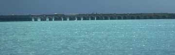
Photo by Keith A. Forbes
2003. 53 years old, its lifespan of 50 years was almost over. It was damaged extensively with a death involved, during Hurricane Fabian of September 2003. Some re-construction in mid-2003 reinforced the flat spans, casting them as arches. Only one lane was open to traffic until completion in August 2003. The construction caused long, tiresome delays, made worse by timed traffic lights which mopeds and scooters use illegally by going in front, much to the annoyance of persons in cars, trucks and taxis.
2000. July. The Bermuda Government announced in July 2000 plans to replace the bridge with a fixed-span overpass giving clearance of between 30 and 40 feet to marine traffic passing below it but this was done. Instead, repairs in 2001 extended its life. Engineers ere not in favor of replacing the bridge with a new swing bridge because the more moving parts there are, the more likely it is that corrosion and breakages will occur, especially in an exposed location.
1952. Late. Bumping over the old barge bridge became a thing of the past when Kindley AFB's new Long Bird Bridge, built by the US Military, was officially opened. (Technically, at that time, it was part of what had been since 1941 the leased Kindley Air Force Base of the US Army Air Corps, later the USAF). It had an expected lifespan of 50 years.
![]()
![]()
A Bermuda National Park. Named after the coney fish (Cephalopholis fulva) one prominent around here. 14.5 acres in size and open to the public from daylight to sunset, free of charge. It is located off the southwest tip of St. George's Island, joined to Main Island, but accessible by road only via the North Shore Road in Hamilton Parish. It has an interesting, undeveloped park and beaches, also a noisy motor cycle track. Its northernmost tip is called North Point and was the western terminus of a railway bridge that once ran to Ferry Reach. The public beaches are in the Department of Environmental Protection but are frequently littered with bottles, plastics, wood and more. Camping was once a popular seasonal event but is no longer allowed, for reforestation.
![]()
So-called because it once housed convicts, especially in the days with the British Army had its major garrison here as well as the British government's Royal Navy. the latter then used obsolete warships as floating prisons, prison hulks, initially at New York City during the American Revolution for prisoners-of-war, then later in Bermuda for white civilian convicts brought over from Britain and Ireland. In 1799, the British government towed the hulk Somerset to this part of St. George's Harbour, hence the name. By 1824, two such hulks were located here while others were at the Royal Navy Dockyard in Sandys Parish.
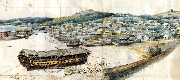
Convict hulk in St. George's Harbour
Today, it is a nice residential area for non-felons but the name has stuck. Prominent features include a group of condominiums. See photo below.
![]()
North shore, a little west of Fort St. Catherine. A small water hole. Named after the American Coot Fulica americana, a bird once abundant here. It was dark grey with large green legs. Breeding adults have red head shields.
![]()
Sometimes called Fort St. Catherine Beach because it is next to the fort, this is where the first colonists waded or were transported by small boat ashore in 1609 from the reef-wreck of the flagship "Sea Venture." From here, they saw wild boars and promptly pigged out with a vengeance. They also saw turtles, lobsters and crabs galore during their 42 weeks in Bermuda before proceeding to Virginia. Until the late 1980s, only guests of first Holiday Inn, then Loew's Inn, then Club Med in succession, who leased and operated the hotel (see photos above) above from the Bermuda Government, could use the beach. When the new replacement Government-leased hotel is completed in 2020 it is expected this will be a public, not private, beach.
![]()
 A lovely body of water separating
Ferry Reach and the mainland, continuing to St. Georges Harbour and Castle
Harbour.
A lovely body of water separating
Ferry Reach and the mainland, continuing to St. Georges Harbour and Castle
Harbour.
The area is a very popular for camping by permit-approved local residents in the summer, dotted with tents. It is also a place remembered by the world community, especially Canadians, as the place where on July 3, 1996 Bermudians committed the worst, most brutal, most animal sexually-depraved, most violent and inhuman racial murder of any woman anywhere in the world, against a 17 year old Canadian visitor, Rebecca Middleton. In June 2006, the Parks Department cut down without explanation the casuarina tree that had become a memorial to Rebecca above murdered just feet away. The area Includes Whalebone Bay, Bermuda Government-owned public beach, little used by non-local Bermuda residents and tourists. So-named after the presence here many years ago of a whale carcass.
Ferry Point Park at Ferry Reach is a wonderful coastal park area. Ferry Reach itself is that narrow body of water linking St. George's Harbor to the open sea at Coney Island. This area of Bermuda was once the main route for people and goods travelling from St. Georges to the mainland. A ferry crossing was established in the 1600s, which connected St. Georges to Coney Island. On the right is the open Atlantic Ocean. The park has some interesting historic monuments, including the Martello Tower, one of many once British Army fortifications that once ringed the Town of St. George, and Burnt Point Fort. The military cemeteries nearby are sad reminders of the soldiers who came here to defend Bermuda and did not go home but died here from cholera or Yellow Fever while doing their duty.
![]()
 Ferry Reach Road, St. Georges.
Many British Army soldiers died in Bermuda
during one of the dreaded yellow fever outbreaks, especially during the
1850-1866
period when more British Army regiments arrived either because of the perceived
threat from the USA towards a British colony in their Atlantic backyard or
because of concerns about Irish Fenians. The latter had fought (and lost) a
battle in Canada but had also stirred up considerable trouble in the USA, some
as new immigrants. .After the yellow fever epidemic of 1853 and the many deaths it caused, the
British Army Garrison in Bermuda kept about half its soldiers encamped at
Ferry Point. Many of the soldiers died of yellow fever, some with their wives
and children too, and were buried in two
cemeteries located at Ferry Road in St. Georges. They were buried by their
comrades with full military honours and their graves had proper regimental
tombstones, The smaller one, Ferry Point
Military Cemetery, now stands simply as a small walled area, with no visible
memorials. There is evidence that there were several headstones in the 1950s but
it is believed they were relocated to the Grenadier Lane cemetery in St.
George's. In 1782
barracks had been built near the site of the Ferry Point Cemetery and the walled
area was where livestock had been kept. It had varied uses over the years: it
was the site of a cockfight in 1785, a cemetery by the early 19th century and
later it became a garden. Ferry Reach Military Cemetery was established later
and may have been a result of both the Ferry Point Cemetery being full due to
the high death rate of the Second Battalion, 56th Regiment (West Essex), of
which nearly 230 of its officers and men died from yellow fever. It prompted a
growing awareness that it was better to locate yellow fever cemeteries further
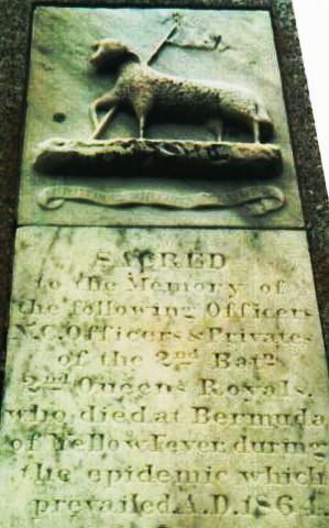
away from places of habitation. It has a large cross and two other memorials to
commemorate soldiers from the 2nd Battalion 2nd Queens Royal Regiment who
died during the yellow fever epidemic of 1864.
Ferry Reach Road, St. Georges.
Many British Army soldiers died in Bermuda
during one of the dreaded yellow fever outbreaks, especially during the
1850-1866
period when more British Army regiments arrived either because of the perceived
threat from the USA towards a British colony in their Atlantic backyard or
because of concerns about Irish Fenians. The latter had fought (and lost) a
battle in Canada but had also stirred up considerable trouble in the USA, some
as new immigrants. .After the yellow fever epidemic of 1853 and the many deaths it caused, the
British Army Garrison in Bermuda kept about half its soldiers encamped at
Ferry Point. Many of the soldiers died of yellow fever, some with their wives
and children too, and were buried in two
cemeteries located at Ferry Road in St. Georges. They were buried by their
comrades with full military honours and their graves had proper regimental
tombstones, The smaller one, Ferry Point
Military Cemetery, now stands simply as a small walled area, with no visible
memorials. There is evidence that there were several headstones in the 1950s but
it is believed they were relocated to the Grenadier Lane cemetery in St.
George's. In 1782
barracks had been built near the site of the Ferry Point Cemetery and the walled
area was where livestock had been kept. It had varied uses over the years: it
was the site of a cockfight in 1785, a cemetery by the early 19th century and
later it became a garden. Ferry Reach Military Cemetery was established later
and may have been a result of both the Ferry Point Cemetery being full due to
the high death rate of the Second Battalion, 56th Regiment (West Essex), of
which nearly 230 of its officers and men died from yellow fever. It prompted a
growing awareness that it was better to locate yellow fever cemeteries further
away from places of habitation. It has a large cross and two other memorials to
commemorate soldiers from the 2nd Battalion 2nd Queens Royal Regiment who
died during the yellow fever epidemic of 1864.
![]()
Retreat Hill. Built 1837-1840. Near the Town of St. George. Not accessible to the general public despite being classified with the nearby as a World Heritage site. An eastern fort. A product of the major refortification of Bermuda that began with the establishment of the Dockyard at the West End in 1809. In his review of the defences of the island in 1828, the Duke of Wellington, then Master General of Fortifications, noted that the "objects to be attained by this Work are to direct the fire from Seven heavy Guns on Traversing Platforms to be mounted on two of its sides upon the Ship Channel to command the Southern approaches to Fort St. Catherine and to afford collateral assistance to the other Works of the position". (The position was that of Retreat Hill centered on Fort Victoria).
Fort Albert, named after Queen Victoria's husband, Prince Albert, is a pentagonal moated redoubt completed in early 1842 and has a small interior keep. It was described in some detail in 1842 to the American Government by the American spy Albert Fitz sent to make a special report on the British Army's and Royal Navy's weaknesses in Bermuda. It is one of several carved from solid limestone rock at huge British Army expense into Retreat Hill. It commanded the channel along the eastern coast of St. George's Island. It was positioned to bring guns to bear on enemy vessels trying to head for the Dockyard. In 1852 the only plan record that survives of the first phase of Fort Albert is preserved in a sketch of the forts at Bermuda made that year by Lieut. Frederick Prime, an American spy. The drawing shows that the fort was constructed to the Duke of Wellington's specifications, but in addition, it had two eight-inch howitzers and two ten-inch mortars, thus incorporating the three types of artillery of the day, the cannon (for low level and long-range), the howitzer (for higher level, shorter range) and the mortar (for high level, short range, for "plunging fire" again the unprotected decks of ships).
The fort was constructed of Bermuda stone, with some details in the harder limestone, probably carved at the dockyard, and had a deep ditch with reverse fires and a "Keep" for housing the officers and gunners. In 1865, Fort Albert was modernized for four ten-inch Rifled Muzzle Loaders by the British Army. It used to be accessible - until the infamous building in the 1960s/1970s of the Lowe's Inn ( later Holiday Inn, later Club Med, later abandoned) hotel, until the hotel's destruction in mid 2008 to make way for the new hotel expected to be completed in 2020. Perhaps then this old fort will once again be open to the general public.
![]()
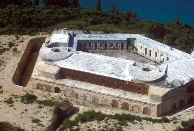
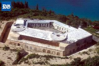
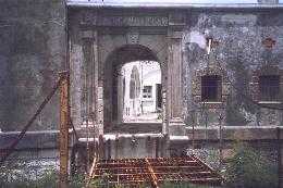
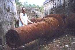
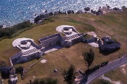
Paget Island, St. George's Harbour. Not accessible to the general public although classified with the nearby Town of St. George as a World Heritage site. A special visit must be arranged. This island on which Fort Cunningham (above) is situated is on the northern side of the original ship channel into St. George's Harbour. It is 36.26 acres in size and was defended from 1612 until the end of the First World War. Richard Moore, sent out from England as first Governor of Bermuda in 1612, decided it was the most important place to be defended. He had platforms for guns cut on the southeastern end of the island as this overlooked the entrance to the channel. This appears to be below the present site of the fort). Governor Daniel Tucker succeeded Moore in 1616 and ensured the construction of another battery below and in front of the original semi-circular platform. In 1619, the third Governor, Butler, built a new platform.
These first forts - Paget and nearby Smith's - were all near the ocean. Although periodic repairs were attempted during the next century, none lasted. The rocks on which the lower battery stood were probably undermined by constant pounding of the waves, particularly in winter. The upper part was removed for a state of the art iron skin fort - with two iron fronts instead of masonry walls. Known originally as Gibraltar shields, only in Bermuda were they made into continuous straight walls, one for five guns and one for two. Seven huge guns for the shields were found in archaeological excavations in 1991, two of only six known examples to have survived anywhere of the British Army 38 ton, 12.5 inch caliber Rifled Muzzle Loader guns of the 1880's. The fort and its massive guns have been allowed to deteriorate badly.
Two photographs above by Bermuda Online Editor and Webmaster Keith A Forbes
![]()
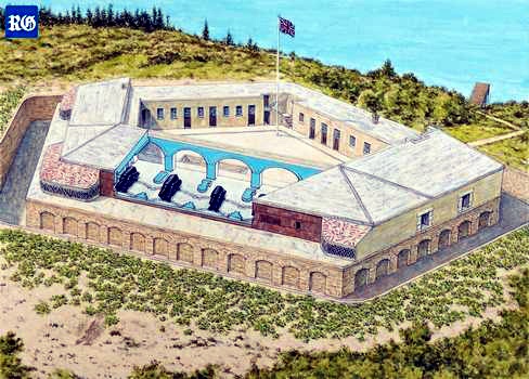
Fort St. Catherine, Bermuda Tourism photo
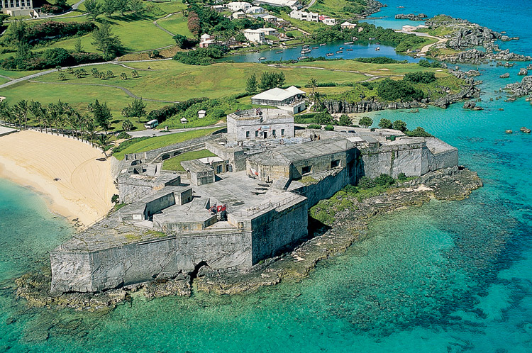
The iconic fortification in eastern St Georges, first established in the early years of Bermudas settlement from 1612, one of Bermuda's most spectacular attractions. The fort, overlooking the beach - Discovery Bay - where Bermuda's first involuntary settlers came ashore from the shipwrecked Sea Venture flagship in 1609, is nearly two miles north east of the town of St. George. The biggest of all Bermuda's many forts built by the British Army to defend its British colony from all foreign invaders. It was built on the orders of Governor Richard Moore by the British Army's Miners and Sappers, later the Royal Engineers, to repel the Spanish, French - and, much later, the Americans. The first stone fort on the site was built in 1614, only a few years after the island was claimed by the Crown, and has been rebuilt several times over the past 400 years.
In 1793, Captain Andrew Durnford strengthened the battery at St. Catherine's Point and built a new battery with a guardhouse on the hill behind the fort. Major Thomas Blanchard replaced the upper battery with a circular fort in the 1820s. There was a massive reconstruction from 1865 to 1878. It included 25 foot thick concrete embrasures and casemates, so that the fort could be rearmed with five rifled 18 ton muzzle loading cannons. They could send a 400 pound shell half a mile to pierce 11 inches of solid iron. Even more armament was added later, to defy an enemy who never came. In its heyday, it was the ultimate fortress to deter enemies. It was a training ground for local forces and the British Army in the early 1900s. It is the seventh and last built on the site. The building offers a classic showcase of British forts, complete with guns. The fort has cannons, tunnels, ramparts and a drawbridge over a dry moat. The fort re-opened on February 14, 2000 after a five month closure from considerable structural damage caused to below it by sea erosion in a 1999 hurricane. Features include replicas of the British Crown Jewels, a fascinating series of historical dioramas recently cleaned and repainted for the first time since the 1950's, a new 53 inch video screen in the theater, new mannequins in the exhibition area and George, the resident ghost.
In the fort's Old Artillery Store, see the dioramas depicting Bermuda's earliest history. The Powder Magazine, now restored to 19th century war readiness, offers audio exhibits and an antique weapons collection. The Keep has an audio visual show on Bermuda's many other forts and their history, as well as records of the many British regiments that once garrisoned Bermuda. There is a small admittance fee to the fort. To date, in non British flags, only the flag of the State of Maine has been flown, for a specific photo opportunity well publicized in Maine. The Fort is also available for group tours, special events, receptions and corporate functions.
Fort St. Catherine is is part of the Unesco World Heritage site of St Georges. It's present-day form was constructed during the 19th century, and stayed in use until 1900. It was turned into a tourist attraction in the 1950s and once featured a production of Macbeth, starring Charlton Heston. He starred as Macbeth in a spectacular floodlit production of the Shakespearean play staged on the ramparts. Unhappily, he suffered from a chronic case of road rash after falling from a rented moped while sightseeing before one of his performances. But he didn't cancel - instead, his buttocks and thighs were creamed with a soothing lotion applied by a blushing local lady.
Beyond the reach of Bermuda's public transportation bus system, it's accessible by local mini bus or take a taxi, or a rented moped. The coastal and inland views from here are awesome..
In World War 2, an American magnetic loop was installed at the fort. It is the first major landmark seen by cruise ship visitors. The main shipping lane is a few cable lengths north. It is how cruise ships and other vessels arrive and depart.
![]()
Another name for Discovery Bay Beach, where the colonists landed after being shipwrecked on a nearby reef.
![]()
It had a water well 124 feet deep, in use until World War 2. There was both an inner and outer moat. It was armed with eighteen 32 - pound cannon. It too is one of several carved from solid limestone rock at huge British Army expense into Retreat Hill. It commanded the channel along the eastern coast of St. George's Island. It was positioned to bring guns to bear on enemy vessels trying to head for the Dockyard. It was severely damaged in the building in the 1960s/1970s of the Lowe's Inn (later Holiday Inn, later Club Med, later abandoned) hotel, until the hotel's destruction in mid 2008 to make way for a new hotel by 2012. Perhaps then this old fort will once again be open to the general public. In its heyday it was the finest of all the forts that once surrounded and defended the town of St. George, the most complex fortification beyond the Dockyard.
![]()
This small but historic fort is more of an observation post than a fort. It is a mile due south of Fort St. Catherine along the coastal road called the Cut Road, and the same distance east of the town of St. George. It was constructed between 1612 and 1615 and takes its name from Sir Thomas Gates, Governor elect of Jamestown, Virginia, from 1609. Because he was shipwrecked off Bermuda along with Admiral Sir George Somers and colonists from the flagship "Sea Venture," he governed Bermuda from 1609-1610 before he became the first Governor of Virginia in 1610. Its chief attractions today are its stunning views of open sea and its site at the edge of the "Town Cut," the tailor-made narrow channel leading from the open sea into St. George's Harbor. It offers a perfect vantage point and a photographic opportunity for observing at very close quarters large cruise ships carefully navigating the Town Cut to enter St. George's. It was badly attacked by vandals on October 2001.
![]()
![]()
A Bermuda National Park and Reserve.
![]()
Howard Bay
![]()
| Banjo | Also Bartram's or Mullet. 1.25 acres, Mullet Bay, off St. George's Island. It was named Bartrum's in honor of John Tavernier Bartrum, a grandson of the English naturalist John Tavernier. Born in Lincolnshire in 1811, Bartrum came here as a member of the British Army (37th Regiment of Foot) in 1832, purchased his discharge in 1837 and resided at Ferry Reach until his death in 1889. He became famous for his book The Cage Birds of Bermuda in 1879. |
| Bremen | On the list of Bermuda National Parks and Reserves. 0.25 acre, east of Smith's Island, St. George's Harbor. |
| Brangman's | Originally Moore's Island, or Southampton Island. 2 acres, between Castle (opposite it) and Nonsuch Islands, Castle Harbour. Part of the Castle Group. Historically important. Southampton fort is here, built in 1612. |
| Brook's | 0.85 acre, north of St. David's Island, St. George's Harbor. |
| Burt's | North of St. David's Island, St. George's Harbor. |
| Castle | Originally King's Island, 3.5 acres, Castle Harbor. One of the "Castle Group." It has the historically important King's Castle stone fortification, dating back to 1612, built by Governor Richard Moore, the oldest standing English fortification in the New World and oldest standing stone building in Bermuda. It contains the Captain's House, built in 1621, the oldest standing home of Bermuda stone and the oldest standing English house in the entire Americas. Archaeological excavations are almost continuous. Recently, a King George III half penny was found there, dated 1775, legal tender in Bermuda during the American Revolutionary War, and 15 pieces of rare Bermuda Hogge Money dating back to 1615, the largest collection of this ever found. The historic buildings are overlooked on the summit by Devonshire Redoubt, built in stone in 1621 to replace one destroyed by fire in 1619. It was from the King's Castle fort that the only attack ever recorded by the Spanish against Bermuda was repulsed in 1614. Two shots were fired from the fort at the two Spanish ships sighted just outside the channel into Castle Harbor. The planned invaders headed out to sea without knowing the fort had only one more cannonball left. The fort was improved over the centuries and even saw active duty in World War II. The ancient English forts on these Castle Islands are without parallel in North America, standing evidence of the beginning of the coastal defense system of the overseas British Empire. |
| Charles | Charles' (Old Castle), 3.5 acres, another in the "Castle Islands" group of Castle Harbour, with prime historical importance for its original fortification. |
| Coney | 14.5 acres, open to the public from daylight to sunset, free of charge. It is located off the southwest tip of St. George's Island, joined to Main Island, but accessible by road only via the North Shore Road in Hamilton Parish. It has an interesting, undeveloped park. But it also has a noisy motor cycle track. |
| Cooper's | 77.5 acres, south east of St. David's. Historically significant. Now joined (since 1941) to and part of St. David's Island in St. George's Parish. So-called after a William Cooper from London, one of the original colonists in 1609. In 1612 it was claimed by Christopher Carter in payment for his share of ambergris forfeited to the Bermuda Company. He spent years there digging in vain for what he thought was buried treasure. In 1614, Governor Moore had built the Pembroke Fort at the south eastern end. It had two cannons mounted on it. The fort was destroyed by US forces building Fort Bell from scratch and in the process destroying many Bermuda islands for the war effort, during World War II. Then, both all of Cooper's Island and much of St. David's Island were taken over by the US Army at Fort Bell which created a road linking this island with St. David's Island. In 1945 Fort Bell was replaced initially by the United States Army Air Force, later the United States Air Force. As Kindley Air Force Base, the lovely Cooper's Island beaches were a hugely popular attraction exclusively for USAF personnel. In 1960 part of Cooper's Island was occupied by a purpose-built NASA space tracking station to gather tracking and scientific data from all its spacecraft, satellites and planetary probes. Personnel from NASA used the beaches. In 1970, the USAF was replaced by a USA Naval Air Station but the NASA tracking station continued. In 1995, the US bases left, NASA also left and the superb once-exclusive to US Forces beaches became public. Afterwards, Bermuda's weather radar system was located on Coopers Island. |
| Ferry | 1.5 acres, south west of St. George's Island and north of Coney Island. It is named after the horse ferry that used to come here until the late 19th century. It was then the only connection between St. George's Island and Main Island. A bridge connects the island with Ferry Point behind it. |
| Goat (2) | Off Cooper's Island, near Nonsuch Island, southeast of St. David's Island, St. George's Parish. |
| Governor's | On the list of Bermuda National Parks and Reserves. 1 acre, St. George's Harbor, near St. David's Island, between Peggy's Island and Paget Island. Its old ruined fort, Smith's Fort, was once the dominant feature. It was named for Governor Moore who in 1612 to 1613 began the fort as a way to command the vulnerable but then strategically important channel nearby. By the time Moore's term ended, 11 guns were in the fort. One of the publicly inaccessible forts but historically important. In 2001 a skeleton more than 200 years old was found buried and unearthed here during an archaeological dig. The skeleton was the second to be found buried in Smith's Fort. The latest skeleton, a male estimated to be in his early 20s, was discovered in one of the fort's "Merlons'' which is a large rampart part of the wall, between which cannons would be fired. The fort was originally built in 1613, and the foundations of two towers built in Bermuda stone were discovered two years ago. In June 1999, another skeleton was found on the same site, only yards from the current skeleton and both appear to have been laborers working on rebuilding Smith's Fort in the 1790s. The fort was modified at that time by St. George's first mayor, Major Andrew Durnford who was also a Royal Engineer. The Royal Engineers were an army corps responsible for constructing forts and bridges. Major Durnford was responsible for modernizing Bermuda's forts following the American revolution, and destroyed all but the footings of the original fort before rebuilding it. Modifications to the fort were deemed necessary at the time to fortify Bermuda as one of the British strongholds in the New World. The individual just discovered was buried in a nightshirt and possibly a shroud, as pins for the sheet and buttons for the shirt have been found with the skeleton. In addition, a coin or medallion was found in the area of the heart and was perhaps in a pocket as it had fragments of cloth adhering to it. The coin was a major find and helped to date when the man was buried, but the cloth that has corroded to it prevented them from reading the date. Archaeologists believe that the two skeletons were those of young men. The latest skeleton was remarkably well-preserved and the man had an almost perfect set of teeth and no visible signs of trauma or injury. The two men had been buried in coffins and although many nails were found the wood had completely rotted away. They may have been victims of yellow fever which claimed many lives in Bermuda over several centuries. The skeletons were sent overseas for analysis, but there were no obvious signs on either of any injury. They will then be kept in the care of the Bermuda Maritime Museum. Smith's Fort is one of the fortifications at the east end that are now on the UNESCO World Heritage list and the work by Professor Barka and Harris was instrumental in having the forts added to the list along with the town of St. George. |
| Grasbury's | 0.75 acre, southeast of Annie's Bay on Cooper's Island, Castle Harbor. |
|
Green |
Continuation of Nonsuch, St. George's Harbor. |
| Hen | 2.75 acres, north-west of Smith's, St. George's Harbour, St. George's Parish. With a campsite operated by and requiring the permission well in advance of the Bermuda Government's Department of the Environment (Parks). Now used by Cub Scouts. In October 2011 a skeleton was found buried there. It may have been that of Gunner Thomas Squires. In 1825, on September 3, then based with a field battery on Hen Island, he was injured during a storm on the island and subsequently died from those injuries. It is believed he was buried on the island. |
| Higg's | 5 acres, St. George's Harbor. On the Bermuda National Parks & Reserves map. |
| Horseshoe | 2.25 acres, St. George's Harbor. On the Bermuda National Parks & Reserves map. |
| Idot | Near Nonsuch, St. George's Harbor. |
| Little Oswego | 0.73 acre, east of Oswego (Great), off St. David's. |
| Little Rogue | Off Ferry Reach. |
| Little Scaur | Between Grazbury's and Long Rock, south of Annie's Bay, St. David's. |
| Long Rock | 1 acre, northeast of Grazbury's and Little Scaur, Castle Harbor |
| Nonsuch | The
island, originally Nonesuch Island, of 14.5 acres, is in Castle Harbour,
west of Cooper's Island, south of St. David's. An old English name,
given by first settlers, after a former Royal palace in Surry, England.
It has small, pristine, untouched beaches and a fresh-water marsh.
Bermuda Government-owned and approachable only by sea, specific
permission from the Bermuda Government agency involved is needed to
visit, primarily for educational environmental purposes. Its trees are
mostly Olivewood, Palm, Bermuda Cedar and casuarina. Its main occupants
are the cahow bird (but no nests), butterflies, skinks, silk spiders and
the longtail bird. It was privately owned from 1700 to 1860 and
variously used as a grazing land once for deer then other animals.
When it was acquired by the Bermuda Government in 1865 it served as a
mostly or exclusively civilian-built yellow fever quarantine station,
ships' quarantine station and hospital, for yellow fever, cholera and
smallpox victims, with a dock and various buildings including a mortuary
and cemetery on the eastern side of the islander. It continued as the
quarantine station for quite some time, officially until 1905 but
unofficially for longer as shown below in 1922.
In September, 1922 - as told by the late Bermuda-based author and nun Sister Jean de Chantal Kennedy - the Royal Mail steam packet ship Chignecte sailed towards Hamilton with six Sisters and Mother Fidelis aboard, all of whom were intending to take up teaching duties at Bermuda's Roman Catholic school of Mount St. A. Agnes Academy in Hamilton. Two days into the trip two of the seamen came down with a rash and therefore could not proceed into the port of Hamilton but had had to run up the yellow flag and await the medical officer. He diagnosed the sailors ailment as small pox and although the ships doctor disagreed the passengers were ordered into quarantine. Parents and their children were brought to Coney Island for quarantine where the conveniences were far better, but twenty-one other passengers, including the Sisters, were required to endure hardships of many kinds at Nonsuch Island. Because Nonsuch Island had been abandoned seven years earlier the weary passengers arrived to see empty, deteriorating buildings, small and inadequate, the dreary graves of former victims of the disease and the keepers cottage on this desolate rock. There was not even a tree except by the morgue. Fortunately for them, Dorothy Tucker, a trained nurse, whose mother was on the ship, accompanied Doctor Percy Shelley to Nonsuch Island where she believed her mother to be. However, her mother actually was quarantined on Coney Island but Dorothy had to now stay at Nonsuch Island because of her exposure to the sick. Doctor Shelley visited the island daily and found no signs of smallpox among his patients but nevertheless, he assigned two of the Sisters to take the temperature of all the patients once a day. These infirmarians were Sister Lucia and Sister Theophane. Supplies came regularly from the mainland and Dorothy assisted by two of the Sisters prepared meals and washed the dishes. As if the crowded, cramped quarters, lack of sufficient fresh water and the monotonous daily existence were not enough, a hurricane struck but the shark oils turmoil caused preparations to be made and by the time the hurricane struck all had been secured. They sought what shelter they could get in the corners and closets and awaited the dawn. With the lulling of the storm, a temporary canvas covering was put over the roof and held down by blocks of stone, and life resumed its even tenor for a while. On the Sunday after the hurricane Mother Fidelis asked Sister Marie Louise and Sister Rita Vincent to play their mandolins for recreation. Before long the other passengers were making their way nearer to the sounds of music and Mother invited them to join the Sisters and soon all were together around the cottage balcony. Some asked for their favorite hymns and be- fore the recital was over most of the familiar hymns, both Catholic and Protestant, had been played. When the time of their exile was about to come to a close, a further three weeks were added to the quarantine because a young man coming to teach at a boys school was discovered with the rash. Mother Fidelis, an accomplished artist who had her water colors and art paper with her, decorated one of the plain paper napkins with which they were provided, painting wild roses around the border and printing in gold ink the names of the passengers to celebrate Dorothy Tuckers birthday. Mother Fidelis also painted a greeting card with the following words: A heartfelt wish for Dorothy, who, imitating her patron saint showered on the quarantine exiles the roses of kindness, thoughtfulness and self sacrifice. God bless you, Dorothy. God keep you. God love you and give you many happy returns of your birthday. The Nonsuch Exiles." Mother Fidelis evidently had her own ideas about the particular manner in which God was to bless Dorothy before the recurrence of her birthday. She thought she saw - and very much approved of-a budding romance between Dorothy and the Doctor. Dorothy had confided to Mother that she was engaged to marry a man in the army but Mother dismissed the military man without even a thought. She had picked Doctor Shelley and apparently Dorothy agreed for they were engaged by Christmas and married at Easter. Community annals tell us that Dorothy cherished the paper napkin and card given her on that memorable day. Finally the days of isolation drew to a close and the Quarantined sailed into Hamilton Harbor in early October 1922 and the Sisters prepared for the delayed opening of their school. From 1928-1931 the island was on loan to the New York Zoological Society as a marine research station. It was was occupied by Dr. William Beebe and Dr. John Tee Van and it was from this base that the historic deep descents by the famous bathysphere were organized and accomplished by Dr. William Beebe and staff. They used the island and - once they were disinfected lest any traces of the diseases were still present - its buildings for their deep water diving experiments. An Admiralty water barge, a surplus-to-requirements former Royal Navy pinnace earlier sunk was re-floated, moved to the island and was again sunk, this time near the north shore to serve as a breakwater and for fish-holding tanks. It became known as the Sea Fern. When they left, the island then became a British-type Borstal - a junior training school for delinquent boys, after which it was abandoned for 12 years. During World War 2 the island, then completely uninhabited, was rendered even less accessible with the building on islands nearby from massive Castle Harbour dredging entirely at US taxpayers expense of what was first the US Army's Fort Bell, than the USAAF then USAF then US Naval Air Station base (that lasted until 1995). After that base was built but before the end of that War, the island is believed to have been silently - with no publicity - and infrequently used as a graveyard for a small number of non-British, including German, seamen killed from ships sunk by German submarines in the Battle of the Atlantic and brought to Bermuda for burial, but with limited space left on the mainland for enemy corpses. In 1951, it was the site of the rediscovery of the endemic Bermuda petrel or cahow (Pterodroma cahow) once common on the island when it and other islands nearby were discovered in 1609 when British colonists first arrived, but disappeared from being eaten by colonists. It was thought to have been extinct for over 300 years. The entire island was acquired by the Bermuda Government in 1964, as part of its nature reserve, bird and wildlife system, through funds donated by the New York Zoological Society. The Cahow project was begun here by Dr. David Wingate (he retired in 2000 as Government Conservation Officer after an amazing career, having devoted his entire working life to conservation generally and the re discovery in particular of the cahow), thanks mostly to him, which created world headlines. His wife Anita, also a conservationist, died in the effort and is buried on the island. Now the Nonsuch Island Nature Reserve is a living museum, a re-creation of Bermuda's native flora and fauna, of huge ecological importance. Limited escorted field trips, for special-interest groups only, began in 2000, from the-then named Bermuda Biological Station for Research (BBSR) for $75 per person. There is also a week-long Nonsuch Island Natural History Camp every year (usually in June) for local high school students, at the nature reserve. Students camp out under the stars, sleep on lilos or camp beds, bathe with solar showers or cold water from a bucket. The camp, offers students aged 15 to 18 a unique opportunity for hands-on learning about natural history from local experts. Students are based on Nonsuch Island and learn about Bermudas terrestrial and marine environments with field trips to a wide range of habitats. The camp is run by Bermuda Audubon Society and Bermuda Zoological Society with the support of the Department of the Environment and Natural Resources, which allows use of Nonsuch Island as the camp base. Visitors can access the islands surrounding waters by kayak and by snorkeling. The shipwreck on the north edge of the island is one of the only shipwrecks accessible to snorkelers rather than scuba divers, and interesting to explore. Snorkelers can free dive through openings the ships hull and find an impressive range of reef fish. |
| Ordnance | The only island in the old town, this one is 1.75 acres and man-made. There were once several islands here. The present island incorporates what was Ducking Stool, Frazer's and Gallows. One stored munitions for the British Army and Royal Navy. Another was where people convicted of capital crimes or witchcraft were hanged. It is now permanently connected to St. George's Island by a bridge so cunningly designed that it does not seem to be a bridge at all. It was a US Navy submarine base when the USA entered World War 2 two years after the British. Cruise ships berth here. Several of the most prominent attractions of the town are located here or nearby. Today, the island has a small park for choice views, a statue of Admiral Sir George Somers who founded the town in 1609, and one of the two cruise ship berths. |
| Oswego | Also known as Great, 2.5 acres, St. George's Harbor. |
| Paget |
Paget Island's location
Fort Cunningham, Paget Island St. George's Harbor, 36.75 acres. With several lovely, often deserted, beaches. Owned and operated by a division of the Bermuda Government. Named after William, fourth Lord Paget who also gave his name to Paget Parish on Main Island. in 1609 when Bermuda was colonized it was heavily timbered with endemic Bermuda Cedars, right to the water's edge. There were also Bermuda Palmettos, native Buttonwoods, Red Mangroves, Black Mangroves, in the shade of which grew endemic Bermuda Snowberry, etc. At various times later, it was also called Peniston's, Pennistones and Pennystones after Anthony of that name who came to Bermuda from Saffron Walden, Essex, England and lived here. It was purchased by the Honorable George Forbes when known as Paget Ford Island. It and nearby Smith's Island were whaling centers. This island's principal feature is massive Fort Cunningham. A much older fort was here in 1612, another battery was constructed in 1619. In 1722, when Colonel John Bruce Hope became Governor, major work was done on Paget Fort (or Queen's Fort as it was sometimes called). It seems likely that the rocks on which the lower battery stood were undermined by the constant pounding of the waves, particularly in the winter. It took several years to complete the repairs on both Paget and nearby Smith's Forts, at great cost. In 1746 so many prisoners-of-war were brought in by Bermudian privateers that the only place available to accommodate them was Paget Fort. They were guarded by locally-quartered troops and had a food allowance of one shilling a day. More construction took place in the 1750s. In 1790, Major Andrew Durnford, Royal Engineer, re-built a part of the sea battery at Paget Fort, but it was destroyed in January 1791 by a violent gale. In 1793, with the threat of war between the UK and France, which would have affected Bermuda and the Caribbean as well, the Governor directed Major Andrew Durnford, Royal Engineer, to build a new Barbette Battery on the height of land above Fort Paget on Paget Island. It was called Upper Paget to distinguish it from the original fortification. What became Upper Paget Fort was later built on and enlarged as Fort Cunningham. Those who visit Fort Cunningham have been able to see the remnants of Upper Paget Fort. In 1797, Paget Island was bought by Captain Francis Forbes Hinson, descended from Dr. George Forbes. Hinson was a complex, eccentric and wealthy man, a mariner, shipbuilder, whaler and farmer. On Paget Island he added orchards, created pastures and cultivated planting land. He was also said to have planned to catch whales in an unusual way. He had been impressed by the efforts in 1780 of an American Zephaniah Pinkham who had arrived in Bermuda to teach locals how to resurrect the once-famous local whaling industry by applying modern methods including cutting up whale blubber with spades to increase profit and reduce waste. He ordered and received a huge whale net from England made out of stout cordage. One evening he planted it in the sea across the Narrows Channel leading to Murray's Anchorage. Instead of catching a whale he caught a French brig-of-war trying to sneak a look at Bermuda. He made a good profit from that transaction. But when his mother and eldest son died on Paget Island he lost interest in Paget Island, bought property in Salt Kettle, Paget on the main island and lived there until his death in 1832, after which his estate that then still included Paget Island was offered for sale. The fort was replaced in the early 1820's. It was much altered beginning in 1875 to contain two iron fronts instead of masonry walls. Because Captain Thomas Cunningham, Royal Engineers, after proposing its creation earlier, supervised the commencement of the re-building by Royal Engineers of massive Fort Cunningham on Paget Island, the fort was named after him. Known originally as "Gibraltar shields," only in Bermuda were they made into continuous straight walls, one for five guns and one for two. Seven huge guns for the shields were found in 1991, two being of only six known examples to have survived anywhere of the famous British Army 38-ton, 12.5-inch caliber Rifled Muzzle Loader guns of the 1880's. By 1912 Paget Island had become derelict. It was later acquired by the UK's War Department. During World War 2, when the island was still owned by the UK's War Department, it was a prisoner of war camp for some Germans or Austrians - only one of whom, Charles Koeppel, 74 years old in the year 2000, has survived. He was born in the USA but his parents were Austrian. His family tried to leave New York for Europe in 1941 but were captured and interned. Guards from the Bermuda Volunteer Rifle Corps (part of the Bermuda Regiment since 1965) then included William Soares, John Mello and Peter Adams. In the 1960s, the island was the base for Bermuda's Junior Training School, for young severe delinquents, based on the concept of a British Borstal, Unfortunately, most tourists cannot visit Paget Island because there is no regular scheduled boat service. The fort, in Bermuda Government hands, has been allowed to deteriorate. With permission in advance directly from the Bermuda Government's Department of Youth, Sport and Recreation, local and overseas groups camp on the 20 acre campground site each year, only one group at a time with a maximum of 70 campers, at a local cost and more than double the cost for non-Bermudian campers. It is also the Bermuda headquarters of the Bermuda Police-led Duke of Edinburgh-inspired Outward Bound programs. To service these two functions, the island has many outbuildings for different purposes. There is also a sports playing field. A Bermuda Government-operated boat visits at fixed times from the Town of St. George to bring supplies to campers and, by appointment and a fee, other visitors.
Fort Cunningham from the air, artist impression of what it once looked like |
| Peggy's | Off Smith's Island, St. George's Harbor. On the list of Bermuda National Parks and Reserves. |
| Pudding | Small and barren. South of Stocks Harbor and west of St. David's. Its position saved it from destruction when the USA military bases were built from 1941. This was when it once again got the unofficial name of " Grog Island" - from the fact that a lot of drinking went on here, as it used to 300 years earlier. |
| Rogue | 0.25 acre, off Ferry Reach. |
| Rushy | 1.5 acres, south of Castle Point, Tucker's Town. A nature reserve. No landing without official permission. |
| St. David's | During World War Two, more than three quarters were taken over for the
construction of the American military base. The now closed US Naval Air Station was
located here for over 50 years. Once St. David's really was an island, 510 acres,
originally one of the six principal Bermudas. It was connected in the 1930's to the
mainland by the Severn Bridge, since dismantled. Today, it is connected to the mainland by
a perimeter road skirting St. George's Harbor. St. David's Islanders have always been
different to most other Bermudians. Some still have distinct characteristics of American
Red Indian heritage. The St. David's Lighthouse has an interesting historical backdrop.
Built in 1879 and periodically refurbished, it still serves as a beacon for mariners.
It was constructed to stop St. David's Islanders from luring ships with other kinds
of lights to come too close to the reefs and get their bottoms torn out for easy
plundering.
When the lighthouse defeated their illegal activities, they became fishermen and excellent pilots. Also well worth visits are the Great Head Battery and Park and, when open (usually on a Wednesday), Carter House, on the former US Naval Air Station, an excellent example of an historic Bermuda homestead saved from destruction when the US military arrived in 1941. It is a living museum of Bermudian history. Clearwater Beach and Park at Annie's Bay on Cooper's Island off St. David's is a 36 acre site with two public beaches closed to the public from 1941 to 1995 (during the 54 years Cooper's Island was a US Navy reserved area). It has nature trails and fine views of Nonsuch Island and Castle Harbor. |
| St. George's | Also known as Tortoise, and Tortus. 703 acres, Bermuda's first colonized island. Includes World Heritage Town of St. George. Now joined to Main by the Swing and Longbird Bridges and the Causeway. One of Bermuda's six principle islands. Historically significant. |
| Smith's | 61 acres, in
St. George's Harbor, St. George's Parish, was named for Sir Thomas Smith
or Smythe, the first Governor of what later became the Somers Isles
Company, an office he still held at the time of his death in 1625. He
was an empire builder of immense energy and ability. The island is
historically very significant, Bermuda's first settlement. It was here
that Carter, Chard and Waters, who got the reputation of being the three
"Kings of Bermuda" from 1610 to 1612, settled when they were
the first accidental permanent colonists in Bermuda. They built cabins
of palmetto, planted beans, watermelons, tobacco, maize, fished of the
coast, hunted wild hogs, salted bacon and fish they caught and even made
a fresh water catch. When the Plough arrived from England on July 11,
1612 with the first party of planned colonists, it went first to St.
David's to discharge them then went two days later to an anchorage on
the south shore of Smith's Island. Carter, Chard and Waters proudly
displayed to Governor Richard Moore the varieties of garden produce they
had grown. Moore was delighted because the Somers Isles Company in
London had supplied him with 81 varieties of seed to try in Bermuda.
Many of the first crops Virginia and the later American colonies had
ever seen were planted on Smith's Island.
It was the original home in Bermuda of the first planned settlers and they even made rock ovens for their food from the local limestone until they moved to St. George's Island and the Town of St. George in the summer and autumn of 1612. The local whaling industry originated on Smiths Island. Soon after its successful start, stations opened in Smiths, Southampton and Sandys Parishes. The hunt for ambergris continued. But the chance of finding the valuable substance was remote. So the search diverted to the huge mammals. Oil from blubber was used locally and in Europe. The bones were a boon to women concerned about fashionable form. They were used in corsets. Locally, the meat known as sea beef was enjoyed by most, but not all, residents. Since 2015 new discoveries on Smiths Island have helped archaeologists paint a clearer picture of what life was like for Bermudas earliest settlers. The team led by Michael Jarvis from the University of Rochester spent spent five weeks excavating tonnes of soil as they explore sites dating back to the early 1600s. Dr Jarvis and his crew of professors, graduates, undergraduates and volunteers have focused their efforts on the Oven Site on the eastern part of the island, which is believed to have been home to some of the Islands first inhabitants. Dr Jarvis and his team have also carried out further excavation of other sites on the island called the Cave Site, Cotton Hole Bight and Small Pox Bay. The Cave Site remains a real mystery. They found considerable evidence to suggest this was a site where everyone gathered on a regular basis. Theres evidence of eating and drinking and socializing here and ceramics that date back to the early 18th century. They found a few different colored river pebbles that were imported from somewhere else. Small Pox Bay was not a typical military site just inhabited by soldiers. They discovered childrens toys and needles, buttons and hair brushes that would have belonged to women too so it would seem this area was used by families. It is possible Cotton Hole Bight might have been where Bermudas first three settlers, Christopher Carter, Edward Waters and Edward Chard, set up camp on Smiths Island in 1610. At Smallpox Bay, old military buttons from the 19th century were found. The Cave Site does not figure on any of the old maps and was discovered quite by accident. The roof of the cave was very carefully chiseled out by occupants of the time. |
| Tobacco Rock | North of Achilles Bay, near St. Catherine's Point off St. George's Island. It preserves the memory of Bermuda's earliest crop in which at one time salaries and wages were paid. It was intended that tobacco be Bermuda's staple crop and laws were passed in England to protect it as such. But Bermuda soil and conditions were never suitable. |
| Whaler's | Near Smith's Island, St. George's Harbor. |
A Bermuda National Park. Named after Captain Field E. Kindley, US Army Air Force, after whom this road, the former US Kindley Air Force Base in Bermuda - see Former US military bases in Bermuda - and more landmarks are named. Number 53 on your free listing of Bermuda National Parks and Reserves. This is to the east and north of the airport with marine views of Ferry Reach.

Center and right, Captain Field E. Kindley
![]()
Southside. Phone 293-5791. Also named after Captain Field E. Kindley, US Army Air Force, after whom this road, the former US Kindley Air Force Base in Bermuda - see Former US military bases in Bermuda - and more landmarks are named. At the former Officers' Club at the former Kindley AFB/USNAS military base, now civilianized. There are 4 asphalt courts, fees. Tennis attire is mandatory.
![]()
Ferry Reach, north side. An unusually-placed and very interesting but not easy to access because of the scrub and vegetation nearby small lake or large pond. A Bermuda National Park and Nature Reserve. Just off the Railway Trail. So-called as it was once used for lovers and others with amorous intentions to go skinny-dipping. Was once a favorite spot for British Army soldiers based in Bermuda in barracks at St. George's to invite local girls to this place. Some locals now use it for the same reason.
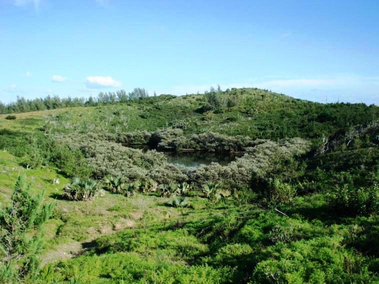
Lover's Lake
![]()
See "Causeway."
![]()
Built from 1823-1828 by the British Army then in Bermuda, with some help from the 96th Regiment from 1825 during its Bermuda assignment. An egg-shaped fort and with walls as thick as nine to 11-feet, designed by the British Army to be largely resistant to cannon fire. It was restored in 2008, including bringing in an "18-pounder" cannon from Fort St. Catherine to have a cannon mound on top of the building as it did in the 19th Century. The fort is open from 10 a.m. to 2 p.m. Monday to Friday in the summer and in the winter by appointment only, by calling the Parks Department.
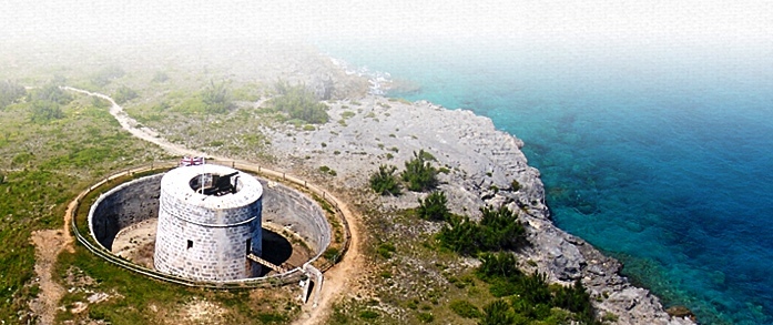
This is the only one in Bermuda ever built as part of the unique system of British military fortifications that once was so prominent along the English coast from Kent to Sussex and spawned their own name in British history. The only other Martello Tower built overseas beyond the UK is in Barbuda, near Antigua. This tower replaced two previous fortifications at this site, earlier built between the 1790s and 1822. Major Thomas Blanshard, Royal Engineer, oversaw its construction of Bermuda limestone between 18221822. The earlier Ferry Island Fort nearby had multiple guns arrayed to cover the water westward, while the Martello tower used a single gun with 360° traverse to cover all of the surrounding area. Two other Martello towers were planned but never built. They had been intended as British Army fortifications protecting the old Royal Naval Dockyard against possible French or American attacks. This one was built after the one on the island of Barbuda in the Caribbean, after those in England.
Like its predecessors in the UK, it has an ovoid footprint with the thickness of its walls ranging from nine to 11 feet. It is surrounded by a dry moat. The tower's purpose was to defend the Ferry Reach Channel and so impede any attack on St. George's Island from the main island of Bermuda, and attacking vessels from slipping through Castle Harbour and the channel between Ferry Reach and Coney Island. The main channel by which vessels reach most parts of Bermuda west of St. George's, including the Royal Naval Dockyard, on Ireland, the Great Sound, Hamilton Harbour, The Flatts, Murray's Anchorage, and other important sites, carries them around the east ends of St. David's and St. George's Islands, where the coastal artillery was always most heavily concentrated.
This one had garrison of 24 men and one officer and two ammunition stores. Originally, on the south and south east coast of England, 103 towers were built between 1805 and 1812 to resist a potential invasion by Napoleon. They were built of brick, 13 foot thick on the seaward side, stood about 30 foot high and were equipped with a cannon on the roof. 74 were built along the Kent and Sussex coastlines from Folkestone to Seaford between 1805 and 1808, the other 29 to protect Essex and Suffolk. 45 of the towers still remain, but many are in ruins or have been converted, so only 9 remain in their original condition. Two supporting forts were built on the south coast at Dymchurch and Eastbourne. The round, curved appearance of the Martellos was implemented to enable the garrison of soldiers and officers that inhabited them to have complete 360 degree views. The wide roofs made an ideal stage to hold a cannon, which was placed on a pivot and so also to rotate 360 degrees. The thick, stone walls made the Martello a sturdy platform, and also highly resistant to enemy cannon fire. Some of the Martellos also had a moat around them as a further protection from attack. Often, a single doorway is found 5m off the ground that could only be accessed by a removable ladder. They typically 2 or 3 floors high, and a base of 24 men plus 1 officer occupied them. The men lived on the first floor which was divided into separate rooms for cooking and sleeping. There was a cistern within the fort to provide the men with water, which was refilled with rain via an internal drainage system that linked to the roof. A fireplace was built into a wall on the first floor for heating, bathing and cooking. The ground floor was used as a stock room, where supplies of ammunition plus food & drinking water were kept. Martello Towers still exist in England, often as tourist attractions or landmarks, but are rare in former British colonial outposts such as Bermuda where their purpose was not only to repel the French but also the Americans after the American wars of Independence, War of 1812-14 and American Civil War when some hawks in the northern USA wanted to attack Bermuda for its open support of the Southern states.
The tower was restored in 2008 and an 18-pounder cannon brought from Fort St. Catherine was mounted on top.
2016. May 3. The Bailey bridge going over the moat (see photo above) at the Martello Tower in St Georges was replaced after 46 years with the help of the son of the man who originally built it. Robin Gray, managing director at local metal working company Ornamental Iron Works, was on site at the tower at Ferry Point, following in the footsteps of his late father Donald who incorporated the company in 1963. In 1970, the firm was commissioned to design and build a footbridge to allow access from the land to the middle section of the Martello Tower along with a ladder to allow access to the bottom of the moat.
![]()
A Bermuda National Park. Has fine marine views of Mullet Bay.
![]()
See Bermuda Cuisine.
![]()
With a small beach. A Bermuda National Park. With fine marine views of the North Shore overlooking Mullet Bay.
![]()
![]()
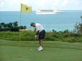 Closed
at this time but reopening by April 2021 when the new St. Regis
Hotel opens.. 1
Park Road, St. George's GE 03. North of and near Town
of St. George. Not on bus route. Phones: Office 297-8067 (fax 297-2273); Pro
Shop 297-8353; Golf Pro 297-3660; Tee Times 234-4653; Maintenance 297-8370;
Restaurant/Bar 297-1836. An 80 acres scenic 18 hole par 62 course over
4,043 yards, first opened in 1985. This was one of the last designed by Robert
Trent Jones Senior prior to his retirement. Cruise ships pass by. Extensively
renovated in most of 2006
to 6,000 yards and redesign by top British golf professional and winner of six
Major tournaments Nick Faldo, by his corporation Faldo Design.
Closed
at this time but reopening by April 2021 when the new St. Regis
Hotel opens.. 1
Park Road, St. George's GE 03. North of and near Town
of St. George. Not on bus route. Phones: Office 297-8067 (fax 297-2273); Pro
Shop 297-8353; Golf Pro 297-3660; Tee Times 234-4653; Maintenance 297-8370;
Restaurant/Bar 297-1836. An 80 acres scenic 18 hole par 62 course over
4,043 yards, first opened in 1985. This was one of the last designed by Robert
Trent Jones Senior prior to his retirement. Cruise ships pass by. Extensively
renovated in most of 2006
to 6,000 yards and redesign by top British golf professional and winner of six
Major tournaments Nick Faldo, by his corporation Faldo Design.
For golfing visitors will be arriving at the airport on one of the commercial airlines or cruise ships, the closest cruise ship berth is the Town of St. George, about 2 miles away to the south. Until it closed, many cruise ship visitors played this course. Buses (# 1 or 3 or 10 or 11) go part of the way.
The 18th hole is named after Bermuda's first Governor, Richard Moore. One of the greens overlooks historic Fort St. Catherine.
Re-opened briefly in part in May 2011 after being closed since July 2008, as a joint venture with the Bermuda Chamber of Commerce, the St Georges Club and the government's Economic Empowerment Zone (EEZ). The course was then maintained at a similar level to municipal courses in the UK. But because it was losing money for the Bermuda Government which owns the course and the latter wanted to allow for building of a planned adjacent new Park Hyatt hotel it was again closed. The hotel development never began until April 2017, which is why the golf course has remained closed.
When the new St. Regis Hotel in completed in 2020 the Bermuda Government, course owner, has confirmed it will be run (although will still be owned by the government) by the hotel development company. Golf will then be offered to both St. Regis Hotel guests and the general public.
![]()
.jpg)
.jpg)
.jpg)
.jpg)
There are hundreds more of these British Army gravestones
Junction of Grenadier Lane and Barry Road, on the eastern shore of St. George's, overlooking the Warden Hole and the Narrows, with Grenadier Lane named for the 2nd Battalion of the Grenadier Guards. The Battalion was banished to Bermuda in 1890 and 1891 for insubordination. London was too hot to hold them according to the New York Times, which also reported that the troops were so unhappy about the heat in Bermuda that further instances of insubordination occurred. Whatever the circumstances of their exile, the presence of the Grenadiers provided the chance for a year of extravagant entertainment, receptions and balls. HRH Prince George, who later became King George V, visited Bermuda during this time, a cause for even more celebration on the island.
It is a 1.66 acre walled cemetery. This now Bermuda Government-owned and Bermuda National Trust maintained facility beyond the Old Town contains a large number of 160 year old graves of officers and men of various regiments and units of the British Army who died in Bermuda. It is no longer active as a burial ground but is of great historic and military significance to Bermuda. It was primarily a cemetery for British Army units based in Bermuda yellow fever victims. It was part of the St Georges Garrison, the earliest establishment of the British Army in Bermuda. There are 256 memorial sites and the names of 539 individuals appear on the memorials. The majority of the deaths they record occurred during the yellow fever epidemics of 1830-1870. The three main monuments are for the yellow fever victims of the Royal Artillery, the Royal Sappers & Miners and the Queens Regiment. It is thought this cemetery was closed about 1870 when the new military cemetery on Cemetery Hill (St Georges Military), Secretary Road was opened.
Cemetery Hill, off Secretary Road. This beautiful graveyard overlooks Murrays Anchorage on the North Shore and is divided into two sections side by side of which the eastern one is mostly civil and the western military. Bermuda stone walls were erected to separate the two cemeteries, but some military graves ended up on the wrong side of the wall, and there are also civilian graves just inside the entrance to the military section. The larger southern, or higher in the civil section, area was for the Church of England and the northern lower section, below the main pathway, was designated for Roman Catholics. Markers denoting this division are visible on the main pathway and on the wall opposite the main gateway.
The entire hillside is a peaceful place. The land for the western cemetery, an area of 1.09 acres, was purchased in 1868 from Mr. and Mrs. J.D. Musson. The new burial ground, which bordered the old civil section known as St. Georges Cemetery, was named St. Georges Cemetery (Military). The absence of mention of yellow fever as a cause of death in the military cemetery is unique in St. Georges graveyards, although two of the remaining memorials mention fever and enteric fever, now known as typhoid.
One of the most significant graves is that of Scotsman George MacKenzie Samson, VC. Petty Officer Samson was the first Royal Naval Reserve to be awarded the Victoria Cross, Britains highest award for gallantry, at Gallipoli, Turkey, in 1915. Born in Carnoustie, Angus, in 1889, Samson was passing Bermuda while serving on a merchant ship when he developed pneumonia and died upon landing. Samson was given a full military funeral.
![]()
Appointed under the Parish Councils Act 1971. See under "Parish Councils" in Bermuda Government Boards.
![]()
On the site of the Old Club Med. Expected to open in April 2021.
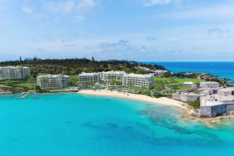
St. Regis Hotel Resort, Bermuda, when completed in 2021
2019. November 1. Construction of an East End development is on time and on budget, the finance minister announced this morning. Curtis Dickinson told MPs that the St Regis hotel in St Georges is expected to open for spring 2021. He added: This project has and continues to provide jobs for Bermudians in the construction phase as well as jobs for Bermudians once the facility becomes operational. This is a historic project for the tourism industry, the St Georges community and Bermuda as a whole.
Mr Dickinson was speaking in the House of Assembly to announce the execution of the Government guarantee on behalf of Hotelco Bermuda Holding Ltd. The guarantee relates to loans to finance development costs and expenses related to the construction of the resort. A development agreement was signed with Hotelco before a groundbreaking ceremony in May 2017.
Mr Dickinson said that under the guarantee the Government cannot be legally required to fund more than $25 million to repay the lender should Hotelco be unable to fulfil its obligations. He added: The financing being guaranteed is provided under a loan facility maturing in 15 years. Mr Dickinson said that the Government would be compensated for providing the guarantee. He added: Also of note is the fact that initially the developer invested a greater sum of their own equity capital into the project and is a sign of good faith and a show of confidence, by the developers, in the viability of the project. Mr Dickinson said the Government guarantee relates to the bank loans and not the developers equity. He said that as of September the total investment in the new development was $65 million and was 100 per cent funded by equity of the developers.
Mr Dickinson said that the 120-room resort will include a casino, spa and golf resort. He added that the resort will potentially provide for many opportunities for local residents and businesses to participate first in the construction of the development and eventually in the running of this tourism facility in the East End.
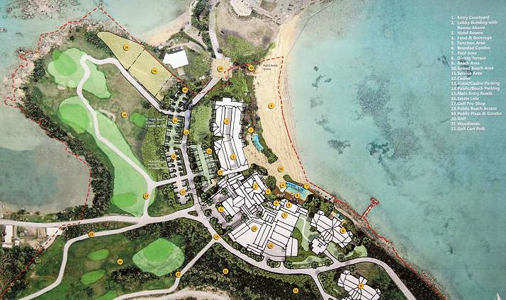
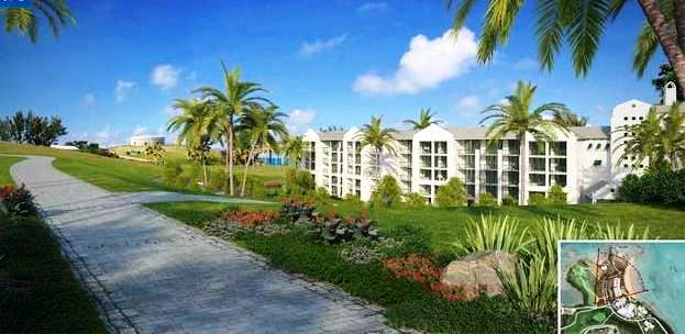
2019. July 16. Developers are hoping to complete a comprehensive makeover of St Georges Golf Course before the end of next year. Hotelco Bermuda Holding Ltd, which is building a new hotel and residences near St Catherines Beach, is also revamping the former government golf course, which was closed down by the clubs trustees more than a decade ago. Now the group is asking for the publics support in keeping motorized vehicles and horses off the course as work progresses on the reconstruction of key course features, including green and tee boxes. December 2020 is the target for the completion of the course overhaul. Meanwhile the 120-room hotel, which will be operated by St Regis, is about 30 per cent complete, according to Hotelco Bermudas general manager Laura Purroy. She added that the residences are about 15 per cent complete and that Hotelco hopes to have a model room and a model residence built before the end of this year. There are 128 workers on site, of whom 68 are Bermudian. Another beneficial economic side-effect of the project is that Hotelco rents 25 homes in the area to house some of its guest workers. It also buys 60 meals a day from Somers Supermart and a further 30 meals from the St Georges Club. On February 18 this year, the Hotelco team began clearing vegetation including small trees from the overgrown golf course. Five months later, the clearing work is now 90 per cent done and the team is already working on the next phase: reconstruction of key features, including tees, greens and bunkers. Ms Purroy said: This work has been a pleasant experience for all the team, especially thanks to the kindness of the people of Bermuda and the beauty of this wonderful island. We are grateful for the support we have received from our neighbours to preserve the work already done at the course. As we advance our efforts to restore this beautiful course to its former glory, we would like to request the support of the public in refraining from driving motor vehicles or riding horses on the golf course. As work progresses, certain golf cart paths will be restricted for the transit of private vehicles. The publics understanding in this regard will help our efforts to create a first-class golf course, which will be enjoyed by the people of Bermuda and our visitors alike for many years to come, a course for the island to be proud of. Salomon Valles, landscape and hardscape supervisor and the chief engineer for the project, said: It is very important to mention that this is mostly a restoration project with just two new holes and the upgrading of the greens contours done by Steve Weisser of Reeds Jones golf architects. Our main mission is to make this golf course environmentally friendly, socially responsible and economically sustainable, and with that in mind we are going to use materials that are available in Bermuda, many of them recycled materials. Recycled glass, for example is being used in new drainage trenches, while the sand dug out during work on the hotel is being used in golf course reconstruction work. Alexander Capitillo, the golf course redesign supervisor, said there would be a change in the route of the course, with the old 18th hole becoming the new first hole, and the 18th now being down near the hotel. He said the tenth, which follows a stretch of spectacular coastline, will be the courses signature hole. A 120-space parking lot will also be provided, close to a practice area, ideal for players to practise their short game. The course will total about 3,600 yards and will be par-60, with 12 par-three holes and the rest, par-fours.
2018. July 24. Members of the public will retain access to a St Georges beach near the new hotel development. The news came as the House of Assembly repealed an earlier Act to develop the new St Regis hotel in the Olde Towne, which had given reasonable access to Fort St Catherine beach, also known as Gates Bay. The replacement St Georges Resort Act took out the word reasonable to reassure people that they would still have unrestricted access. Lovitta Foggo, who represents an East End constituency, explained: We couldnt explain to our constituents what that meant in a real-life situation. The original legislation, passed by then ruling One Bermuda Alliance in 2015, caused concern in the Progressive Labour Party Opposition that the beach might be declared off limits. But Patricia Gordon-Pamplin, shadow home affairs minister, on Friday accused the PLP of playing political football. She highlighted that no concerns were raised by the PLP in 2008 when the same wording was used in legislation for the Park Hyatt development at the same site when the party was in government. Jamahl Simmons, the tourism minister, said the people of St Georges trusted the PLP as a government that listened. He added: The people of St Georges didnt trust the OBA. Mr Simmons said the difference between then and now was the presence of Renée Ming, the St Georges North PLP MP who contested the original wording. She said during the House debate: Access was key. It was never answered by the former administration. The new Act does allow for limited access to the beach by the general public at specified times and to specified areas for hotel events or for maintenance and repairs with the agreement of the minister. Kim Swan, MP for St Georges West, said he supported efforts to increase commercial business viability in the Olde Towne.
2017. May 12. The Bermuda Government provided a guarantee of up to $25 million for the St Regis hotel in St Georges. The guarantee is for a Butterfield Bank loan of $60 million for Hotelco Bermuda Holding Ltd, part of the Desarrollos Hotelco Group behind the luxury development. Finance minister Bob Richards described the move as tangible evidence of Governments commitment to the redevelopment of the tourism sector, noting it will lead to jobs in the construction and tourism sectors. In total, the 122-room project will cost $150 million, which Mr Richards said will be broken down as $90 million funded by equity capital from the developer and $60 million funded by bank loan. The Governments guarantee is limited to $25 million of the bank loan, he told MPs. Ground was broken on the project in a ceremony last week, after many years of waiting for a new hotel for the East End. This is indeed a historic project for the tourism industry, the St Georges community and Bermuda as a whole, Mr Richards told the House of Assembly. We reiterate our belief that there are many factors surrounding the decline in our once pre-eminent industry. One of the key factors is the investment piece: the ability to promote a value proposition for investors in Bermuda hospitality. The financial closing for this project is real world success in that objective. This project will provide jobs for Bermudians in the construction phase as well as jobs for Bermudians once the facility becomes operational. The guarantee provides that the Government cannot be legally required to fund more than $25 million to repay the lender if Hotelco Bermuda Holding Ltd is unable to perform their obligations to the lender. The financing being guaranteed is provided under a loan facility maturing in 15 years. I am pleased that a local financial institution has shown confidence in the project and the tourism sector and Government is delighted that they could assist in making this happen. Mr Richards said it is generally not the policy of the Ministry of Finance to issue guarantees to the private sector unless the matter is of national importance. He continued: However, until recently, the island has not seen a new hotel development for some time and the Government strongly supports this Project and the economic benefits that it will bring to Bermuda. With the hosting of the Americas Cup we must do even more to attract local and foreign capital to our shores to develop our tourism product. At a Tourism Summit held a few years ago in Bermuda it was noted that our competitors are doing a great deal to attract financing for hotel projects, some Governments are going so far as to guarantee the debt in order to finalise the acquisition of the required financing for the project. This is exactly what we have done in order to ensure this development materializes. It is also important to note that the Government will be compensated for providing the guarantee. Also of significance is the fact that initially the developer will be investing their own equity capital in the project thereby delaying the exposure of Government.
2017. May 4. Representatives of the Bermuda Government, Marriott International and developer Hotelco Bermuda Holding Ltd joined together today to officially break ground on the planned 240,000 sq. ft. St. Regis Hotel and seven condominium buildings.
The luxury hotel will feature facilities such as 122 rooms and suites, St. Regis restaurant, bar and wine vault, a casino and 3,000 sq ft of meeting space. a spokesperson said. For guests looking to relax, the resort will feature an 18-hole golf course designed by Robert Trent Jones, a luxury spa and state-of-the-art fitness centre, a club for children and teens, and swimming pools for adult and families. The look and feel of the new St. Regis will reflect Bermudas unique architectural style; OBM International, the master planning, architecture and design firm, has designed the property. The hotel will create economic opportunity in Bermuda even before it opens its doors, starting with 300 construction jobs required to build the project once the work is fully ramped up next year; 80 per cent of those positions are expected to be Bermudian. The project will rise in phases, with Phase 1 being the hotel and 28 residences [14 private and 14 fractional]. Phase 2 will include 42 private St Regis residences and Phase 3 will include 28 private St Regis residences. In addition, there will be seven lots for sale for luxury St Regis villas. St. Regis is part of Marriott International and the new luxury hotel is being developed by Hotelco Bermuda Holding Ltd. After decades of uncertainty over the future of a hotel in St Georges, I am excited to be breaking ground on the St. Regis hotel today. This marks the beginning of a new era in St Georges that will revitalize the town and bring much-needed tourists and traffic to an important part of the island. The construction of the hotel will create hundreds of new construction jobs and we are thrilled about this" said Premier Michael Dunkley "Bermuda is a very special place for us. When we first saw the land three years ago, we knew that it was the perfect spot for a luxury hotel, says Miguel Purroy, Principal and Director of Hotelco Bermuda Holding Ltd. The beachfront location and the incredible history of the site right near the forts and the old town of St Georges are a perfect combination for the resort. We are so pleased to be taking the first steps towards creating new history and guest memories on this site. "Marriott is excited to be working with Hotelco Bermuda Holding to bring this exciting luxury resort to life in Bermuda, says Tim Sheldon, President, Caribbean and Latin America, Marriott International. " St. Regis bridges generations by providing a luxury experience that combines modern conveniences and technology with timeless design and personalized service to appeal to a new generation of global, luxury travelers. We are delighted to be breaking ground on a new St. Regis hotel in Bermuda today, which will be a jewel in the St. Regis family. The hotel is due to open in early 2020, the Government said.
2017. April 29. Ground looks set to be broken at the St Regis hotel resort in St Georges next week. The Royal Gazette understands that invitations have been sent out stating the official ground breaking ceremony will take place at St Catherines Beach on Thursday afternoon. The beginning of construction work would signal an end to nearly a decade of dashed hopes and false dawns for the East End community since the Club Med property was destroyed in August 2008. Mayor of St Georges, Quinell Francis, told The Royal Gazette she was very confident that progress would be made on the development in the coming week. I have spoken with the general manager and the project engineer and it seems that the revised road alignment has been set out. I understand that the permit should be coming in the next couple of days. I am very confident that we will be moving ahead with this project in the new week and progress will be made. There is a genuine feeling of optimism in the community; we have been through this process before but now we are seeing this project move forward. The general manager and project manager have now relocated to the island and this shows again commitment to this project. We are feeling very positive that it will go ahead. Plans to build the new St Regis hotel were approved by planners back in January The development, which will overlook Gates Bay, will feature a 122-key resort with 97 hotel rooms and 25 suites, as well as a casino, restaurant, bar, golf clubhouse and other amenities. The first phase of the project would also include two residential buildings, containing 28 condominiums. Later phases would include another three residential complexes. In March, Michael Dunkley told MPs that he had been assured by a principal of the St Regis development that the hotel would be built before the residences. The Premier was responding to repeated claims by Progressive Labour Party MP Zane DeSilva that he had heard the residences would be built first. St Georges MP Kenneth Bascome would not comment on reports that ground would be broken on the project next week. There are a lot of rumours whirling around that something significant is going to be announced in St Georges next week. At this stage I am not in a position to make any official comment on that or verify those rumours.
2016. October 20. It was announced that the Bermuda Government and the Desarrollos Hotelco Group had finalized the Master Development Agreement for the St. Regis Hotel.
2016. March 2. Government and developers finalized a 262-year ground lease for the St Georges hotel project, it was announced today. Michael Dunkley, the Premier, flanked by East End MPs and representatives from the Desarrollos Group, said that the agreement was a significant milestone in bringing a new hotel to St Georges. It is very clear that this project will generate jobs both in construction and when the resort is operational in a few years times, he said. The development plans for this site include a 120-room St Regis hotel, a spa, a renovated St Georges golf course, residential condominiums and, if permission is granted, a casino. Mr Dunkley made note of the hotel developer and operators previous projects which include a Ritz Carlton resort in Aruba. Desarrolloss commitment to build a world-class resort that harmonizes with the Unesco World Heritage site of St Georges is a testimony of the companys belief in a strong future for Bermuda in both hotel operations and the islands residential real estate, he continued. Craig Cannonier, the Minister of Public Works, said he was excited to see the project move forward, while St Georges MPs Nandi Outerbridge and Kenneth Bascome both said they were thrilled to be one step closer to a new hotel. Mr Bascome said: As I said from jump, this is the real thing and you will see a hotel built on this site. Representatives from the developer said the concept for the resort had been agreed, and architects and engineers were working on a detailed plan. Groundbreaking on the project is expected to take place this year.
2015. December 21. Leases for a proposed hotel development in St Georges were approved by the House of Assembly. While the Opposition expressed support for the 262-year leases, it warned the Government to make sure the public will retain free access to Fort St Catherine Beach. Shawn Crockwell, the Minister of Tourism, said the hotel would include 122 hotel rooms, six estate residences and a possible 90 condos, renovations for the St Georges Golf Course, and subject to Gaming Commission approval a casino. He acknowledged that concerns had been expressed about public access to the beach, noting that access was restricted when previous hotels had been operating in the area. Its a beautiful beach, he said. We already promised that they will provide reasonable access to the beach without any charge at all times and when they want to utilise the beach for private events, they need to ask permission from the minister. [The public] will retain access to the beach. There will be a clear egress to the beach. This is positive going forward. Jamahl Simmons, the Shadow Minister of Tourism, stressed the need to retain public access to the beach, urging the Government not to slip away from that over time. He also said the developers need to be open about the direction of the project so the public are aware of what is happening. We recognise the importance of having another [hotel] property in Bermuda, particularly a property in the East End which has been devastated economically by the absence of this property and the reduced number of cruise ships. I think the people of St Georges will be excited, he said. I think they will be very cautiously optimistic that the Government will keep access open, but we call for greater openness from the developer, greater interaction and a further expansion and continuation of the process. Until the shovels hit the ground, lets keep the lines of communication open, lets make sure people are kept accountable along the way as we go through this process. Lovitta Foggo, the St Davids MP, also stressed the importance of retaining public access to the beach or else the Government could earn the ire of the public. Here is something that may bring much to the area, but at the same time, its taking a valuable asset that many St Georgians enjoy, she said. I just want to put my voice out there on behalf of the people in the eastern area to appeal to the minister to make sure all the checks and balances are in place. Kenneth Bascome, the area MP, thanked Mr Crockwell and his team for bringing the project this far, adding: I can assure the people of St George that they will have access to that beach. I am a part of this team, and I will guarantee you that my voice will be heard should it not take place. Noting the deterioration of the site and the golf course in recent years, he said the new development would help put further shine in the jewel of Bermuda. Mr Bascome added: I can tell you there will be no six years of broken promises because I have told the minister if these folks dont deliver, they need to get on their plane and go to whence they came because [former site developer Carl] Bazarian kept us in limbo so long people say they dont believe its going to happen. Last week the Senate also passed the St Georges Resort Leases as well as The Casino Gaming (Designated Sites) Regulations.
2015. December 9. The Bermuda Government has tabled a series of leases for the St Georges hotel project. The 262-year leases, tabled on Friday, propose a varying rent for the hotel property, which would start at $1,000 per year before rising to $5,000, $80,000 and eventually $100,000 per year. Starting on the tenth anniversary of the agreement, rent payable will increase by 10 per cent every five years. Meanwhile, separate leases offer the developers the golf course for an annual peppercorn of $10. The property to be used for fractional units would also be rented for a token $1 annual fee, but the leases state the government would receive $105,000 for each of the fractional units sold. The lease also somewhat clarifies the proposed public access to Fort St Catherines Beach, which had been an area of concern among some after earlier documents promised reasonable public access. A section states: With the exception of the specific area delineated and marked Hotel Use Only on the tenant covenants, the beach shall remain open to the general public for use (save for with regard to the use of any hotel facilities or amenities on the beach, which shall be reserved for guests of the hotel and the owners and occupiers from time to time of any residential accommodation on the estate only) without charge at all times, except when the tenant or manager of the hotel shall close the beach, or a portion thereof, for such durations as may be agreed from time to time with the minister (acting reasonably) for the purposes of special hotel events on the beach, the maintenance or repairs of, or improvements to the beach. Government has been moving forward with a deal with the Desarrollos Hotelco Group to erect a new St Regis Hotel on the 124-acre site that formerly hosted the Club Med hotel. The St Georges Resort Act, which allows leases and concessions in connection with the development, was passed in the House of Assembly and the Senate earlier this year despite concerns voiced by the opposition, and the Government announced in October that it had finalized the master development agreement for the project.
2015. August 19. After nearly three decades of lying fallow, the East Ends vacant hotel property will get site work before the years end, with groundbreaking for a new resort to commence in the first quarter of 2016. Plans include 122 hotel rooms, six estate residences and a possible 90 condos, renovations for the St Georges Golf Course, and subject to Gaming Commission approval a casino. Concessions for the development, which the One Bermuda Alliance has called the most important hotel development in 40 years, are expected to add up to $30 million over the course of ten years. Shawn Crockwell, the Minister of Tourism Development and Transport, told the House of Assembly that once an agreement was completed in the next few weeks, town hall meetings would follow at the East End to inform residents. An epic debate on the long-anticipated development took up the bulk of a special sitting of Parliament on Monday, with Mr Crockwell questioned at length by Opposition Members of Parliament. Meetings with the people of St Georges are to be held once the developers, Desarrollos Hotelco Group, come to the Island after settling their agreement. The developers will answer concerns of area residents, as well as negotiating with the Corporation of St George over shared sewerage facilities. Responding to parliamentary questions from shadow minister Zane DeSilva, Mr Crockwell told the House that the lead principals for the company are Walter Stipida Sprecase and his son Roberto Stipa Tenreiro. The firm is Venezuelan, and Mr Crockwell said the family travel with interpreters: Mr Stipida Sprecase does not speak English, while his son does. A local company, Hotelco Bermuda Holding Limited, was incorporated on July 17, and ownership figures are not yet available. While the deal comes with substantial concessions for the developers, Economic Development Minister Grant Gibbons stressed that the Islands existing concession laws, dating back to 2000, were out of date. A financial memorandum given to legislators said that the developer intended to invest upwards of $120 million in the construction and development of the St Georges resort. An estimated break on the importation of building materials and supplies over a ten-year period is expected to be between $8 and $10 million, including materials for renovations in year seven of the resorts opening date. Supplies that qualify for a full relief from customs import duty range from air freshener and toiletries to stationery, cups and other standard items stocked in hotel rooms. From its opening until its tenth anniversary, the resort is estimated to receive at least $15 million relief on the hotel occupancy tax, which is a fee paid by guests, at 7.25 per cent of the room rate, upon checking out. Similarly, over ten years, the resort will reap an estimated $5 million on concessions for the employers share of payroll tax although numbers will vary according to the staff. Land tax concessions have not yet been determined, and the property is to be valued upon completion of the development. That figure is not included in the overall $30 million concession estimate. Many details have yet to be settled on the development, which will cover the old Club Med site on land to the south of St Catherines Point. A ground lease and master development agreement will be tabled before legislators when the House of Assembly resumes in November. Questioned throughout Monday nights debate, Mr Crockwell told the House that the residential component of the development may include fractional units. No firm decision has been made but the developers wish to retain the option, and Mr Crockwell said that residences alongside the St Georges Golf Course would not have an impact on the course itself. The developer and operator are keen for as much volume as possible on the course, he said, and are hopeful that a lot of people in the public are going to come and use the golf course. Meanwhile, there will be no restrictions placed on access to the public beach, the minister added. Directors and shareholders for Desarrollos Hotelco Group have been listed as: Maria de Stipa, Isabel Stipa Tenreiro, Elisa Stipa Tenreiro, Miguel Purroy Unanua, Pedro Vera Puente, Roberta Scivani, Maurizio Scrivani, Ms Zanoletti [sic], Mauricio Zanoletti, Giancarla Stipa, Diegio Freyre, Mauricio Zanoletti and Jose Guerrero Gil.
Tabling of lease agreement: November 2015
Estimated groundbreaking: early 2016
Estimated value of concessions offered: $30 million
Time period of concession: ten years
Lease: 262 years is commercial acceptable term
Size of property: 50.51 hectares, or 124.81 acres
2015. July 20. New legislation paving the way for a luxury hotel resort to be built in St George has been welcomed by the towns leaders. The St Georges Resort Act 2015 was tabled in the early hours of Saturday morning by Shawn Crockwell, the Minister for Transport and Tourism Development. MP Kenneth Bascome told The Royal Gazette he was confident the development would now reach fruition, while Mayor Quinell Francis said the tabling of the Act was good news for the whole community. We are on our way to creating something that the town but also the country can be proud of, said Mr Bascome. At this stage on behalf of the community of St George I want to thank the Minister of Tourism and his team for bringing the project this far. What happened with this site previously was never really as concrete as this and I believe these folks will take it to fruition and the Minister has done all his due diligence. I want to thank them for showing faith in St George. We will welcome them with open arms. I believe this is the real thing, and it is very much needed because the property is dilapidated and looks like a jungle. Ms Francis added: Im pleased to see the Act tabled in the House and hope that this resort will now come to fruition. Its good for St George but its also good for the country and will bring in a wide range of visitors to the Island. We are still in the early stages. When we start to see progress on the ground we will be even more excited. Its good news. The Act, which is expected to be debated later this summer, authorizes the leasing of the land to the developer and grants rights, leases, concessions, permissions and the approvals necessary to develop the resort on land lying to the south side of St Catherines point. Work on the new hotel, which will be managed by the St Regis, Starwood Hotels & Resorts brand, is expected to start before the end of the year. I am very excited to announce that the Bermuda Government and the Desarrollos Hotelco Group are now poised to finalise the Master Development Agreement for the St Georges Tourism Development Site, said Mr Crockwell. This is a group that is more than capable of developing a world-class, full-service resort and we are very excited to have them as our partner. Today marks a significant milestone for this development, it is indeed very good news and comes as a result of numerous meetings that the Government, the Bermuda Tourism Authority and Desarrollos have had with both internal and external stakeholders, to negotiate terms and to prepare the relevant documentation. This is a $120 million dollar development and very significant to the revitalization of our tourism industry, the St Georges community and Bermuda as a whole. The proposed development includes 122 hotel rooms, a casino subject to an application to the Gaming Commission and the renovation of the 18-hole Robert Trent Jones designed St Georges Golf Course. There are also plans to build: 90 condominiums, six estate residences, a spa and fitness centre, meeting rooms, swimming pools, a pool bar and grill, a speciality restaurant and a beach restaurant and bar. Mr Crockwell said: This development has the potential to spur other developments and provide exponential employment opportunities. It is crucial to Bermuda and it will have a positive impact on our Island. This Government made a promise to develop a resort in the east end and it is a promise that we are keeping. I must applaud the hard work and commitment of the Ministry of Tourism Development and Transport, the BTA and our consultant on this project, the Hemisphere Group, a Miami-based international real estate advisory firm. Reaching this point is a testament of our focus and efforts to create an inviting business environment to attract inward investment and private sector jobs for Bermudians. This is a very important piece of legislation and I encourage the Opposition to support it as it is a tremendous benefit for all of Bermuda.
2015. July 19. New legislation paving the way for a luxury St Regis hotel to be built in St George has been put before Parliament. The St Georges Resort Act 2015 was tabled in House of Assembly in the early hours of Saturday morning by Shawn Crockwell, the Minister for Transport and Tourism Development. The Act, which will be debated at a later date by MPs, authorizes the leasing of the land to the developer and grants rights, leases, concessions, permissions and the approvals necessary to develop and deliver the St Georges Resort on land lying to the south side of St. Catherines point. The resort will be managed by the St Regis, Starwood Hotels & Resorts and it is anticipated that work will start before the end of this year. I am very excited to announce that the Bermuda Government and the Desarrollos Hotelco Group are now poised to finalise the Master Development Agreement for the St. Georges Tourism Development Site and as such I am able to table the St. Georges Resort Act 2015, said Mr Crockwell. "This is a group that is more than capable of developing a world class, full service resort and we are very excited to have them as our partner. Today marks a significant milestone for this development, it is indeed very good news and comes as a result of numerous meetings that the Government, the Bermuda Tourism Authority and Desarrollos have had with both internal and external stakeholders, to negotiate terms and to prepare the relevant documentation. This is a $120 million dollar development and very significant to the revitalization of our tourism industry, the St. Georges community and Bermuda as a whole. This development has the potential to spur other developments and provide exponential employment opportunities. It is crucial to Bermuda and it will have a positive impact on our Island. This Government made a promise to develop a resort in the east end and it is a promise that we are keeping. I must applaud the hard work and commitment of the Ministry of Tourism Development and Transport, the Bermuda Tourism Authority and our consultant on this project, the Hemisphere Group, a Miami based international real estate advisory firm. Reaching this point is a testament of our focus and efforts to create an inviting business environment to attract inward investment and private sector jobs for Bermudians. This is a very important piece of legislation and I encourage the Opposition to support it as it is a tremendous benefit for all of Bermuda. The proposed development includes 122 hotel rooms and the renovation of the 18 hole Robert Trent Jones designed St Georges Golf Course. The resort will also include: up to 90 condominiums, six estate residences consisting of three and four bedrooms, a spa and fitness centre, meeting rooms, a casino subject to an application to the Gaming Commission, swimming pools, a pool bar and grill, a speciality restaurant and a beach restaurant and bar. A Government statement released this afternoon said: The selection of Desarrollos resulted from a thorough Request for Proposal (RFP) process that had the stated objective To provide a high quality tourism development that will complement the St. Georges UNESCO World Heritage Site designation and accentuate the historical significance of the area while providing economic opportunities for the people of St. Georges and Bermuda. At that time, interest was expressed by over a dozen international development and investment companies which resulted in five written submissions being received by the Ministry of Tourism Development & Transport by the March 31st deadline, 2014. Each proposal was thoroughly reviewed and evaluated incorporating a decision matrix that took into consideration the respondents international experience in successfully financing, building, owning and operating luxury resort developments and their relationships with renowned hotel brands. From this process two short listed finalists emerged and the finalists were invited to make oral presentations to the Economic Development Committee. It was not an easy decision as both short listed finalists submitted impressive proposals that were augmented with very detailed oral presentations that highlighted their desire and enthusiasm for the development opportunity, but most importantly their proven ability to deliver projects was evidenced. Ultimately, Desarrollos was chosen."
2015. March 18. Developer Desarrollos Hotelco Group has signed a statement of intent with Starwood Hotels and Resorts. He made the statement while clarifying an answer he gave to the question in an earlier session of Parliament, when he stated that the Starwood Group had an operators agreement with the developer. Progressive Labour Party MP Lovetta Foggo had asked in the March 11 session what commitments the Starwood Group had made regarding the development of a new hotel at the former Club Med property, officially called the St George's tourism development site. Mr Crockwell said on Monday: I provide clarification that the Starwood Hotels and Resort and Desarrollos Hotel group, the chosen developer for the St Georges tourism development site, have a signed term sheet and [the parties] are working towards finalizing the hotel management and related agreement over the coming weeks. It was explained that term sheet could be defined as the parties statement of intent. The Desarrollos Hotelco Group was selected from five companies to redevelop the 124-acre Club Med site. It maintains a low profile and does not appear to have a website. The proposed development includes a 238-room hotel and the renovation of the 18-hole, Robert Trent Jones-designed St Georges Golf Course. The resort will also include sixteen hotel residences, twenty-four golf villas, sixteen estate residences consisting of three and four-bedroom residences, spa and fitness centre, meeting rooms and ballroom, casino, swimming pools, pool bar and grill, a speciality restaurant. Attempts to develop the property included plans by Bazarian International Financial Associates for a Park Hyatt Resort, which was supposed to open in 2012. In October 2012, the contract was terminated and the Park Hyatt Hotel Act was repealed. Originally built as a Holiday Inn, it changed to Loews and was then taken over by Club Med. It closed in 1988 and was imploded in 2008.
2014. December 13. Developers Desarrollos Hotelco Group have been chosen for a five-star St Regis, Starwood hotels resort to be developed in St George's, starting next May. Phase one of the development will cost $120 million, according to Tourism Minister Shawn Crockwell, and will include 122 rooms and eight residences. Phase two will deliver four large estate villas and 22 golf villas, Mr Crockwell told MPs yesterday, with Opposition members questioning why so little could be gleaned online about the developers. Mr Crockwell called Desarrollos a family business, adding that they had completed due diligence. He said there would be an appropriate press conference on their plans at the groundbreaking stage. The Venezuelan developers, who had an exclusive negotiating period to put a resort on the old Club Med site, saw that period extended in October. It would have expired today. Construction should begin in May and take 16 months. The group supports having a casino at the site, but the final decision to licence it would lie with a Commission. The Minister hailed the news as a "significant vote of confidence, confirming efforts by Government and the Bermuda Tourism Authority to secure direct long term inward investment and permanent jobs. This luxury resort development will be a tremendous positive impact to our Island and we are moving quickly toward finalizing the customary agreements." Mr Crockwell ascribed the delay to Desarrollos assembling its "critical path items for pre-development, development and operation, as well as settling the brand agreement with a selected hotel operator." Yesterday's eleventh-hour announcement for the long vacant brownfield site in St George's was the biggest step since Mr Crockwell declared in May that a Memorandum of Understanding had been signed with the group. The Progressive Labour Party has voiced skepticism about the reputability of Desarrollos during debates in recent months. The Minister hinted that the developers were currently in the process of creating a website that might answer questions. The initial proposal was for a 238-room hotel including a casino, the renovation of the St George's Golf Course, 16 hotel residences, 24 golf villas and 16 estate residences.
2014. June 17. A total of five firms tendered for the redevelopment of the Club Med site in St Georges, MPs have heard. But Tourism Minister Shawn Crockwell declined to name the losing finalist in a contest which saw the field whittled down to two before the Venezuelan Desarrollos Hotelco Group won. "As we have entered into a 120-day exclusivity period with a chosen developer, it would be inappropriate to disclose the name of the other short listed developer during this period," he said. And he explained that if there were problems with the Desarrallos deal the second developer could be called on to take over. Mr Crockwell said: "To disclose the name of the finalist at this stage may unduly prejudice the Government's position." He was speaking after St David's PLP MP Lovitta Foggo asked a series of questions relating to the deal, announced last month. Ms Foggo also asked why Desarrollos had been given a four-month exclusivity period for negotiations and when that time slot would expire. Mr Crockwell said: "The Desarrollos Hotelco Group is a reputable company with a proven track record of success with hotel developments in the Caribbean. They have strong relationships with high end hotel brands and their proposal was well-aligned with the objectives that were set out in the request for proposals (RFP) augmented by a very good oral presentation. The 120-day period was a specific requirement set out by us in the RFP and is a reasonable period of time to allow the chosen developer and the Government to reach a conclusion in the process." The other companies that submitted unsuccessful bids were the Ellipse Consortium, Dolphin Capital Partners, Jambo/Chef and Sutton Park Partners. Shadow Finance Minister David Burt questioned why Desarallos did not appear to have an online presence although an internet search does throw up references to a number of deals the firm has been involved in, including the development of a five star resort in Aruba. Mr Crockwell said the lack of online information in this day and age is unusual but that it was not a cause for concern.
2014. May 23. Government is today set to announce a developer has been signed up for the old Club Med site in St George's. Tourism Minister Shawn Crockwell is slated to make a St Georges tourism announcement in the House of Assembly this morning. And it is thought it will involve the former hotel site, which has lain unused for years since Club Med pulled out of Bermuda in the 1980s. The site could also become the home of the Island's first casino, if legislation allowing gambling in Bermuda is passed as expected next month. Premier Michael Dunkley yesterday declined to comment on the specifics of the announcement. But he said: "There will be a big announcement that has great potential for Bermuda going forward. I think people are going to see, in spite of some of the clouds of negativity we have seen over the past couple of weeks, the work of Government has still gone on and progress has been made. I'm just excited to hear the Ministerial statement in the House when he reads it out. People need to understand how we get here because a lot of people think you just go and find somebody. There was a tourism summit last summer and we had investors from all over the world who came to the table and talked to us about what they thought Bermuda needed to attract people, what type of facilities Bermuda needed. Out of that, the request for proposals was put together for the East End facility and we've worked through that process. The Minister for Tourism Mr Crockwell today must feel tremendously satisfied that he's in this position." Mr Crockwell also declined to comment on details of the deal. But he said: I'm very excited we can make this announcement despite what's been going on, we've been hard at work and I think its going to be a very exciting announcement." St Georges North MP Kenny Bascome, a former Mayor of the Old Town, said: "St George's is the jewel of Bermuda. There are a number of small entrepreneurs that have opened in St George's. they must have some kind of vision that something is going to happen. I hope things work out to allow them to be successful." The former hotel lay derelict for 20 years until the building was demolished with explosives in 2008 and the site cleared.
2013. September 21. Parliament has repealed the Park Hyatt (St. Georges) Resort Act, opening the way for Government to negotiate fresh development deals for the former Club Med site. The Opposition Progressive Labour Party lost no time in supporting the measures but demanded that Government tear up the lease of Daniel's Head as well, as the owners of the 9 Beaches resort had also failed to meet their obligations and owed money to Government. Government charged that the PLP had made mistakes in its handling of the Park Hyatt, sparking lively debate in the House of Assembly. And independent MP Terry Lister welcomed the bill saying its a chance to put the last developer, Mr Bazarian or whatever his name is, behind us and move forward. Mr Lister suggested that the golf course should be developed separately. "The efforts that have been made in the last two years to bring tourists from Dockyard to St Georges have faltered. They have not really worked. We need to do as much as we can to rebuild," Mr Lister said. Former St Georges Mayor Kenneth Bascome said he had spoken to prospective developers of the property and that a new project should begin soon. That led Shadow Attorney General Kim Wilson to question why it took so long to repeal the bill. "We are looking at and recognizing a decision that was made that was entirely inappropriate, that was ill advised, that we asked for the former government to consider carefully before encumbering the country and we got absolute total push back with complete 100 percent push back," responded Health Minister Pat Gordon-Pamplin. Developer Carl Bazarian won the go ahead to develop the 125 acre property in 2008 with a 262 year lease. But he was unable to secure financing and could not meet the agreed deadline to break ground on the project. And the former PLP administration terminated the agreement last year before losing the general election. The repeal Act finalizes the termination of the lease and formally returns the land back to the Government. Ms Gordon-Pamplin described the deal with Mr Bazarian as a mammoth mistake which had made no sense in the first instance and that PLP MPs had failed the country by not questioning it at the time. PLP MPs defended their party's actions, saying all parties to the agreement had acted in good faith, due diligence had taken place but the global financial collapse had soured the investment climate. I don't think we should cast an aspersion on the Government or the parties involved," said Opposition MP Glen Blakeney. But Government whip Cole Simons rose to say that the PLP should admit that it made a mistake as it had not done enough due diligence on the developer. He didn't have the resources. If he had had the money we would have a hotel today. There was no reason why they closed down that golf course when they were nowhere near developing the hotel. People lost jobs and we have nothing to show for it."
2013. January 26. The former Progressive Labour Party Government - which lost power in the Bermuda General Election of 17 December 2012 - severed its ties with US developer Carl Bazarian. However, new Tourism Minister Shawn Crockwell offered no official comment on the status of the long-stalled deal to put a Park Hyatt hotel in place at the East End. Told that Bermuda's Royal Gazette newspaper had learned from a reliable source that the deal had fallen apart, Mr Crockwell responded: It would be premature for me to comment. I have had some provisional briefings next week and the point person from Government will be giving me a briefing on all the developments, especially Park Hyatt. As soon as I have had the briefing I will speak to the press. The long inaction after Mr Bazarians October pledge to break ground on the former Club Med site, once permits were in place, prompted calls from environmentalists for Government to drop its development agreement. The beleaguered project is now mired in legal disputes after the previous government dropped its connection with the developer. Originally hoped to get underway on 2007, the Park Hyatt resort in the Old Town was lately hoped to be finished by 2015.
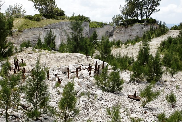
Site of planned hotel never built, Royal Gazette photo
September 2011. Plans for the proposed Park Hyatt resort received planning approval with 45 conditions attached. The Development Applications Board agreed to the controversial plans at a meeting on August 31. E Michael Jones, representative of developer Carl Bazarian, stated: We are very excited to have approval and we look forward to the process of doing the detailed drawings and following that, breaking ground. Park Hyatt is also very excited and looking forward to operating a premier resort in St Georges. I would like to take this opportunity to thank the DAB for their conscientious and careful deliberations of these plans and, on behalf of Carl Bazarian, I would like to indicate that we will honour our commitments to the residents of St Georges. We look forward to supporting the business community and the residents of St Georges and we anticipate that once construction gets underway, this will revitalise the town, which deserves and needs it. Mr Jones said it could take six to nine months to draft the detailed plans and get them approved. He said construction could begin immediately afterwards and was likely to take about two years. An early version of the application was first submitted last September, but was revised due to concerns about plans to adapt Fort Albert into a garden and spa. Revised plans were submitted earlier this year, leaving the historic fort untouched apart from some possible repairs and moving the spa facility to the resorts golf club. The revised plans also proved controversial, receiving hundreds of objections from environmental groups and area residents. The utilities site, which is expected to include a reverse osmosis plant and a sewage treatment facility had been an area of contention between the developers and residents of the Old Military Road area. Residents expressed concern that the site, to be constructed near the entrance to the resort, would produce odour and noise. The developers however maintained that the site would be state-of-the-art and cause no such issues. According to the minutes of the Development Applications Board meeting on August 31, some members of the board still expressed concerns about aspects of the resort, including the utilities site. A section of the minutes reads: In further discussion of the proposal, some members remained concerned about the proposed utilities site and (felt) that there were alternate sites within the resort better suited to that aspect of the proposal. In response, officers reiterated that permission in principle for the utility site in this particular location has been granted by the Special Act. It was therefore not open to members to consider the location at this stage. Instead, they needed to be satisfied that detailed issues were acceptable through a combination of proposed plans and supporting conditions. In this respect, officers felt that the impact of the utilities site could be successfully mitigated.
Among the 45 conditions included in the approval were a minimum of 10ft of existing vegetation along Old Military Road should be retained as a buffer around the utility site. And other technical details, such as the ongoing monitoring of aspects, including the odour and noise of the utility site, must be provided and approved. Other conditions included in the approval touched on the historical aspects of the site, calling for an engineers report on how historic features such as Fort Albert, Fort Victoria and Fort William (Gunpowder Tavern) would be protected or modified. The approval also reiterated that a hotel must be built before any residential units are conveyed or occupied, a condition that had been included in the ground lease on the site. The proposed $300-million resort would also include almost 40 buildings, including a 100-room hotel spread over four buildings, 122 residential units, a redesigned golf course and a fitness centre. An off-site staff housing facility with 90 living quarters is also included in the plans, along with a beachside restaurant on Fort St Catherines Beach.
October 22, 2010. It was announced by then-Premier and Minister of Tourism Ewart Brown that ground will be broken by November 2011 for the new Park Hyatt Bermuda. The hotel will be built on the old Club Med site. Dr. Brown announced that the Park Hyatt group had agreed to become an equity stake holder. Previously, they had agreed to manage the planned new resort facility. Dr. Brown said the hotel chain was going to invest "millions of dollars" into the project which is thought to be costing in the region of $300 million. In 2008 Government signed a 262-year lease with Mr. Bazarian after paying for the demolition of the former Club Med hotel. Mr. Bazarian said the Park Hyatt Group's investment should allay the fears of those who doubted the hotel project would go ahead in the current economic climate. He confirmed that his company had obtained a loan from HSBC and invested its own money into the $300 million development. To date, the Park Hyatt group have had about eight visits including their operations department and their development department. They made this investment because they believe they will see returns on their money. Park Hyatt's Director of Development and Corporate Communications is Laurie Cole.The development will be built "concurrently" Mr. Bazarian said. It will include the 100-room Park Hyatt Hotel as well as 71 hotel condominiums, 39 villa residences and 12 single family homes. Also on the 125-acre site will be an 18-hole Nick Faldo-designed golf course, an 18,000 square-foot spa and fitness centre as well as two tennis courts. Guests will be able to dine at two full service restaurants and two cafés or enjoy the Beach Club. There will also be staff housing for 160 employees and an on-site wastewater treatment plant and reverse osmosis water purification facility. Mr. Bazarian added that the terms of the 262-year lease had not changed with the new investors. "We are waiting on planning. Once we have planning we will go ahead with meeting various construction schemes and then start building. No one has been chosen yet to build the development. We are hoping to break ground in November 2011, but if planning comes through sooner we can begin sooner. A project this size could take 24-30 months to complete."
In December 2008 Luxury hotel chain Park Hyatt signed a management agreement with developer Carl Bazarian to run a new $294 million 5-star hotel at the old Club Med site. The signing witnessed by officials who included Premier Ewart Brown and six-time Major winner Nick Faldo, who will redesign the St. George's Golf Course. Mr. Bazarian said work would begin in 2009 and the hotel should be ready by the first quarter of 2012 or even late 2011. Park Hyatt Bermuda will offer a 100-room hotel, 111 visitor units and approximately 30 fractional ownership units. The resort will also include four eating outlets, a 14,000 square-foot Hyatt Pure spa and fitness center, a private beach club, two swimming pools, tennis courts and nearly 4,000 square feet of meeting and function space. When completed the development will usher in the tourism revival St. George's has been promised for decades. Mr. Faldo has lived in Bermuda for two years. Dr. Brown said attracting developers and investors to Bermuda to build new hotel product was a colossal undertaking. In December 2008 Business Traveler Magazine named Park Hyatt the best hotel chain in the world, another international award for a chain that consistently accumulates accolades. There are 24 Park Hyatt brand hotels across the world with an additional 10 under development. Current locations include; Baku, Beaver Creek, Beijing, Buenos Aires, Canberra, Chicago, Dubai, Goa, Hamburg, Istanbul, Melbourne, Mendoza, Milan, Moscow, Paris, Philadelphia, Saigon, Seoul, Shanghai, Sydney, Tokyo, Toronto, Washington DC, and Zurich.
Time line
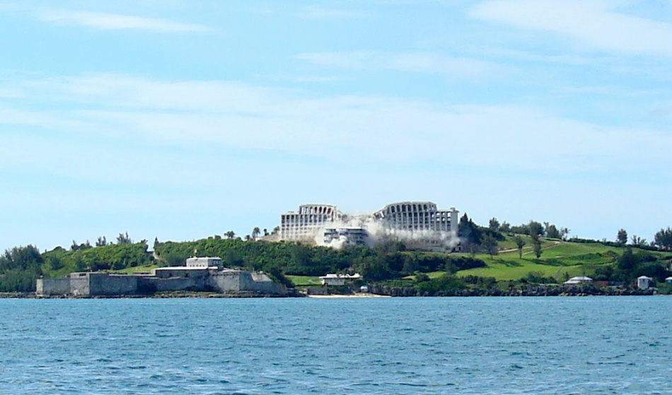
Old Club Med, imploded at 10 am, August 25, 2008. See more details below.
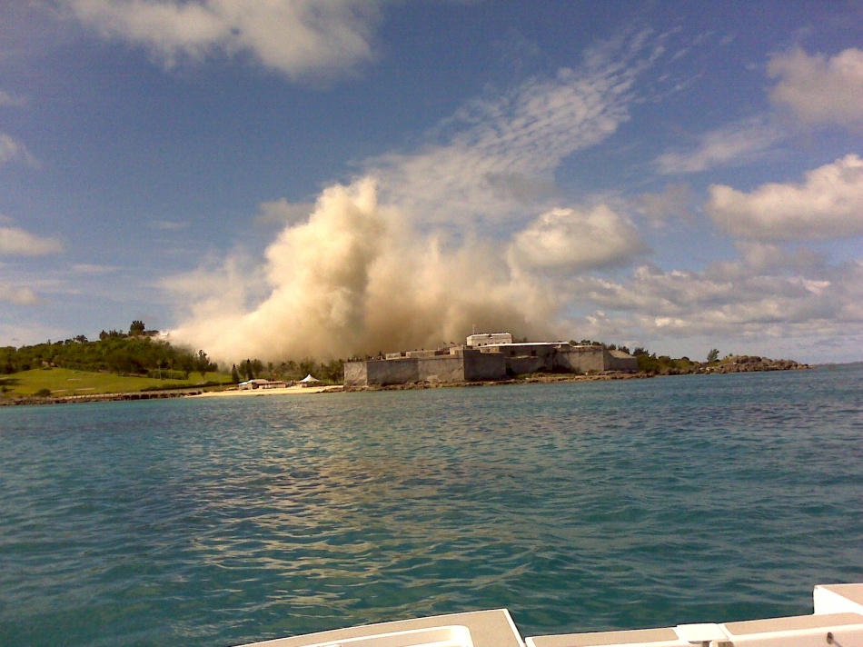
Old Club Med site, after implosion at 10 am August 25, 2008. After more than 2,500 truckloads of demolition debris have been cleared away, construction can begin on the flagship new hotel, to be Bermuda's newest, to be managed by Park Hyatt.
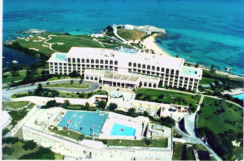
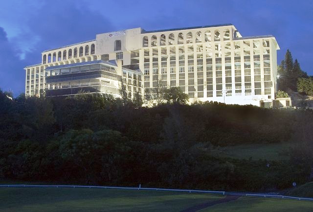
Former Club Med, now historic pictures, imploded, no longer a distinct landmark for vessels and aircraft
1973. February 15. Opening date of large new hotel in St. George's, the Holiday Inn (later, Loews's Inn, later Club Med). It had a sad history and was finally demolished in 2008 in hope of having a new hotel. Present in 1973 were personalities including the Premier, Minister of Tourism and MCPs including Sir Dudley Spurling.
On August 25, 2008 at 10 am the huge building shown above was finally imploded, recorded on television and by the Discovery Channel of the USA, to make way for a new Park Hyatt Hotel. With the property Bermuda Government owned, it had been abandoned since 1989 and was up for lease. The Park Hyatt (St. George's) Resort Act 2008 places ownership of the land south of St. Catherine's Point earmarked for the hotel and golf course in the hands of Government. It will then be leased to developer Addax Holdings Ltd. for Bazarian International who have promised to produce in 2009 or thereabouts the brand-new Park Hyatt (St. George's) Resort. D. H. Griffin Wrecking Company, of North Carolina, won the contract for the implosion of the ten-storey building and began preparing the site for implosion on July 16, 2008. Griffin owner Rusty Griffin and his employees drilled a total of 2,000 holes into the various columns that support the structure. The holes were later filled with dynamite, over 700 pounds in total, to ensure the building's implosion. The explosions were scheduled to bring down the building in a carefully timed and organized manner, like a line of dominoes. Explosions in the core of the building, the old elevator shafts, weakened the centre of the structure first, pulling the wings of the hotel inward. More explosions followed moments later to weaken more of the structure, feeding the collapse. In total, there were 12 "slices" leading outward, each timed to bring the building down onto itself, rather then falling away. T. H. P. of Ohio conducted engineering surveys of the structure to ensure it was imploded safely. All asbestos-containing material were removed from the site before implosion occured and local contractors only will used to remove the debris and rubble as soon as it has been deemed safe to do so. The asbestos was taken to the Government quarry for storage in conditions approved by the Ministry of Health. All living in the area near the site were evacuated from the area temporarily and cared for by the Government at another location. Residents living in GE03 and GE05 postal codes received brochures in the mail and were advised to block their roof gutters. Bermuda Water Consultants monitored air and water for pollution levels to make sure there were no health risks.
The Bermuda Government is committed to handing over a clean site to developer Bazarian International on December 31, 2008, ahead of the creation of a $294 million dollar Park Hyatt hotel to be managed by Park Hyatt, plus residence complex (condominiums, see below) and golf course. The new complex proposed for the Club Med site includes a 200-room hotel as well as 140 condos, some of which will be available for hotel guests, and 40 fractional ownership units. It's a $294 million project that will include swimming pools, tennis courts, five restaurants, bars and an 18-hole golf course designed by champion golfer Nick Faldo. In March 2008, Mr. Bazarian of Bazarian International also announced that he had entered a deal with Park Hyatt hotel chain as the operator and brand of the development.
He also said his company was also interested in enhancing Fort Albert and Fort Victoria, which he claimed were also part of the property. "We'll definitely have it built by 2012. It's going to be spectacular. We are going to keep to the culture of the UN Heritage concept. We want to use the forts and enhance them." Before that can take place, however, David Durham, of Building Blocks Construction, will have to truck away three to four thousand tons of debris. They would try to recycle as many materials as possible, but that the work could take between six to eight weeks. The debris that cannot be recycled will be dumped at the Frederick L. Wade Airport dump.
The move will finally end a deadlock on the derelict facility which has been a source of frustration for St. George's residents since Club Med closed in 1988. It had an uneasy life. It had started as a Holiday Inn, which failed. It became a Loews's Bermuda Inn, which failed, then a Club Med Hotel. The Park Hyatt (St. George's) Resort Act 2008 also sets out the concessions and terms of lease for the resort, placing ownership of land south of St. Catherine's Point in the hands of Government. Developer Addax Holdings Ltd., for Bazarian International, will be granted a 131-year hotel lease. An annex to the Act also asked the House of Assembly and Senate to approve an initial 120-year lease for the additional 11.77 acres of St. George's Club to 'St. G Club Ltd', for an annual rent of $200,000. Regarding the hotel lease, the Minister of Works and Engineering will be responsible for leasing land to the developer for up to 131 years, with an "automatic renewal" for a further 131. The lease for the 180 condominiums (40 of which will be owned by tourists on a fractional basis) will be for 262 years. When the owner is not in the unit, the unit will be voluntarily rented out through the hotel to transient visitors. The fractional units will be subject to all of the services and amenities that are afforded to a regular hotel room, such as housekeeping, bellman, etc. The Park Hyatt development will also include staff housing, The development will also include staff housing (to be situated on land off Redboat Lane North, a sewage treatment and water desalination plant, reverse osmosis plant, beach club, tennis courts, sun deck, docking facilities, restaurants, shops, a spa and fitness centre. Commercial and service vehicles will be allowed to bypass the St. George's Traffic Ordinance 1967, in that they will have access "to travel on certain routes that would otherwise be restricted". They are granted access to the hotel via Government Hill Road and also Wellington Street, and "any other alternative route, as may be necessary from time to time". Speed limits however, will be in force. The hotel concessions granted to the developer by the Act include:
One year's "full relief" on customs import duty for building materials, furnishings, fixtures and construction equipment;
Five years' exemption from land tax for the hotel, fractional and condo units;
Five years' exemption from hotel occupancy tax to the equivalent amount spent on sales, advertising and marketing of the Park Hyatt hotel and golf course;
Five years' exemption from hotel occupancy tax to the value of 50 percent of the amount spent on Bermudian entertainers;
Five years' employer's payroll tax exemption to cover 100 percent of training and education costs for Bermudian employees (to a maximum 90 percent tax exemption);
A reduction in the Bermuda Immigration Protection Act 1956 land-holding charge for first disposition of each fractional share, from 18 percent of the value of the share to 10 percent;
Full exemption from the land-holding charge for first disposition of a condo unit, which must be rented out by the hotel to tourists for ten months of the year. Otherwise the charge is 18 percent of the value of the condo. And if the licence holder opts out of the rental programme, the land-holding charge is ten percent the original value of the condo;
Full exemption from the Bermuda Immigration and Protection (Rental and Use) Regulations 2007 charge on the rental of a unit, provided the condo is rented by the hotel to tourists for ten months of the year.
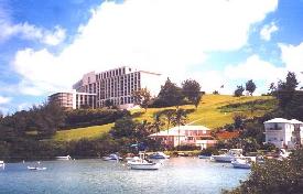 Until
August 25, 2008 it was very big,
shuttered-up building on the
top of the hill near Fort St. Catherine Beach, with
gorgeous sea and land views, among the best in all Bermuda, the dominant landmark in the area by
air and sea. It had a troubled history. It began life as a
leased Holiday Inn. It
failed, the leasehold was sold, became a Loews Inn, failed again, then became a
Club Med resort until 1989, when it again failed. The building reverted to landlord the Bermuda
Government, owner of the land and property. Fort Victoria was leased with the property, and became the
site of the hotel's swimming pool and tennis courts as it was lost forever to
visitors and those who appreciate unique British military property.
Until
August 25, 2008 it was very big,
shuttered-up building on the
top of the hill near Fort St. Catherine Beach, with
gorgeous sea and land views, among the best in all Bermuda, the dominant landmark in the area by
air and sea. It had a troubled history. It began life as a
leased Holiday Inn. It
failed, the leasehold was sold, became a Loews Inn, failed again, then became a
Club Med resort until 1989, when it again failed. The building reverted to landlord the Bermuda
Government, owner of the land and property. Fort Victoria was leased with the property, and became the
site of the hotel's swimming pool and tennis courts as it was lost forever to
visitors and those who appreciate unique British military property.
Smaller picture left, from a different angle, by author Keith A. Forbes, shows another view of the former hotel and fort. The then-derelict site, instead of being without any human occupation, was, until April 2007 when they were finally ejected - the home of trespassers, more than 33 homeless folk who took refuge in the formerly vacant staff dormitories of the once bustling hotel, despite the many "no trespassing" signs. They joined forces to form a Peoples Alliance in a bid to make the derelict building a better place to live. Many of the people were skilled and had jobs but were unable to to afford the Islands high rents and cost of buying a home. They were dubbed Bermudas working poor part of a growing segment of the population caught in the housing trap. They ranged in age from 14 to 56 and bonded together to pool skills and food under the Peoples Alliance banner. They ran the Alliance to ensure each resident has access to food and that their most basic needs were met. Some visited grocery stores to see if they would give food that would otherwise be thrown away. Their efforts were successful and they had a relatively good supply of nonperishable food. They had power and furniture, some found there, others scrapped, plus TVs and more, inside the rooms. The property looked like it had been battered by a strong hurricane. All escaped the exorbitantly high rents and costs of housing elsewhere. They were aware that they would be forced to leave if the property is leased, but were happy that they had a roof over their heads and were not forced to live in Bermudas public parks and beaches. This is a side of life other Bermudians and tourists do not see, except when publicity results when the Police are called. In late 2007 the discovery of asbestos halted plans to demolish the former Club Med and prompted squatters to move back in after being evicted by the Government.
Despite its stunning setting for a top-class resort, the property remained vacant for more than 18 years with several investors putting forward ambitious plans, backed by tens of millions of dollars, only to have them collapse.
May 2008. The plan was changed, to build a Park Hyatt, not a St. Regis, once the present structure is demolished. Blame for the delays has been attributed to the huge amounts of asbestos found in the present building. It was hoped that if and when the property is resurrected it will be bull-dozed and rebuilt as a five-star hotel for an as yet unnamed hotel operator who will agree to the property and land being only leased, not bought outright. This has been the main stumbling block to date. A testing 'signature' golf course is also on the cards to give the new hotel, if built, an extra hook for attracting visitors to the East End.
May 9, 2007. Construction work on the five-star St. Regis hotel at the former Club Med site is to begin this year, Premier Ewart Brown pledged at a public meeting. Dr. Brown said he wanted to reassure pessimists that ambitious plans to transform the derelict building would not go the same way as a string of similar proposals which have collapsed in the past few years. He said work would begin as soon as Carl Bazarian, of Bazarian International, the investment banking firm behind the scheme, completes negotiations over a lease with the Ministry of Works and Engineering. "Carl Bazarian is a very serious and committed developer. Im very confident that he will keep his word. We need to see that building leveled. We need to see it gone. That will the very first phase of the work done. I wanted to come here tonight and reassure you that nothing has got in the way. The brand thats been mentioned is St. Regis. You dont get a much more luxurious brand that St. Regis. Club Med is to St. Regis as a dwarf is to a giant. We are bringing something that can make a difference in the town. I have challenged the mayor and alderman to help make St. Georges alive again. Its been too sleepy. Business doesnt thrive in a town that sleeps. The new St. Regis resort is expected to be completed in three years. It is likely to have up to 150 units, comprising one- two- or three-bedroom apartments and villas, and will be a maximum three storeys high.
1997. The St. George's Renaissance Consortium, backed by Canada-based Quorum, led by Wanda Dorosz, got the nod for a limited-term exclusivity agreement. Costs were estimated at around $80 million and the group wanted to be in business by 2005. They claimed to have spent more than $2 million on the project that would have brought a Four Seasons hotel to Bermuda. The consortium's $220 million plan, unveiled in November 2003, included demolishing the old building and replacing it with a hotel of at least 90 bedrooms and a cottage complex of 90 condominiums, designed in a European style with public squares and fountains. An underground theatre, seating between 400 and 500 people, would be used for cultural events and the consortium had gathered support from several overseas cultural institutions which would have resulted in world-class theatre coming to the island. By March 2005, the plans remained on track, with a much-increased cost estimate of $210 million and the Four Seasons hotel chain set to manage the resort. However, by December 2005 the Renaissance group, with its $220 million worth of financing in place and primed to press ahead, was dealt a major blow when it appeared Government stopped talking to it. The next move was unveiled by Dr. Brown in January 2006 when he revealed that talks had started with US-based KJA Company and Jack Avedikian. Ten months later this agreement was terminated.
In February 1996, Club Med approached Government with a proposal to reopen the hotel by May of the following year. The Government set aside its legal action and compromise agreements were reached on re-licensing requirements relating to fire safety, sewage treatments and room standards. Club Med decided reopening would not be possible until the spring of 1998, but in March 1997 proposed to reopen as a timeshare property. Government responded by re-launching its legal action to take back the lease. The result? Club Med gave up the lease in September 1997. In 1998 the Atlanta-based Camberley Hotel Company was in the frame as the next potential developer. Talks between the company and Government progressed well over the subsequent months and by July the company had come to a labour agreement with the Bermuda Industrial Union and had set early 2000 as a target opening date. A month before the November 1998 General Election, Camberley president Ian Lloyd-Jones said his company's $32-million revamp plan for the hotel would be put on hold until after the poll. The Progressive Labour Party won the election and David Allen replaced David Dodwell as Tourism Minister. Talks continued, but by May 1999 the Camberley deal was close to collapse due to finances, or the lack thereof. By late 2000, Mr. Allen sparked some optimism by announcing that Malaysian development company Aman Capital wanted to redevelop the site. But by December 2001, the plans had effectively collapsed. In September 2002, after a short battle with cancer, Mr. Allen died. Three more bids to redevelop the hotel site were considered by Government, but one of the competing groups got fed up with waiting for a decision by late 2002.
In December 1993, the United Bermuda Party's Jim Woolridge became the first in a string of Tourism Ministers from both major parties to claim that good news on Club Med was just around the corner. He announced that he had met with a group of businessmen from Massachusetts who had viewed the site and were interested in building a new hotel. But before anything could move forward, the Government had to deal with the fact that Club Med still held the lease to the land on which the hotel stood. In 1995, the French resort company proposed reopening 100 of the hotel's 340 rooms and simultaneously slashed its asking price for the building from $32 million to $13.5 million. Its argument was that it would be easier to sell the business as a going concern. But the Government rejected the proposal, as Works & Engineering Minister Leonard Gibbons pressed ahead in taking Club Med to court to reclaim the property, arguing that the company was in violation of the terms of its lease. When the matter went to Supreme Court in August 1995, Puisne Judge Vincent Meerabux reversed his decision on whether to send the matter to arbitration and legal proceedings began that were to continue, on and off, for more than two years.
![]()
A now-disused Anglican church in Wellington, St Georges. Forced to close in 2018 after the number of parishioners dropped to only a handful. The distinctive yellow brick church with a stunning stained-glass window, made by island artist Vivienne Gardner, hopes to find repose as a private home or community hall or pre-school or similar. It overlooks the Mullet Bay playground. Its a piece of spiritual history that means a lot to people who live in the Wellington Slip area. St Peters West was the heart of the vibrant and bustling Wellington Slip community in its heyday in the 1960s and 1970s. Scores of children attended the churchs Sunday school and weekend services were regularly attended by a 100-strong congregation.
The premises became St Peters West Church in 1958, one of three in the Anglican Parish of St Georges alongside historic St Peters Church and the Chapel of Ease in St Davids. Most of the members have passed away now. But back in the day it was the heart of the community.
![]()
Situated to the south-west of St. George's Harbour and west of the Swing Bridge (see below). A bay formed by Stocks Point promontory on St. David's Island to the north, its shoreline to the south and east, and a sand flat to the south-west. A 215-berth marina has been planned for here.
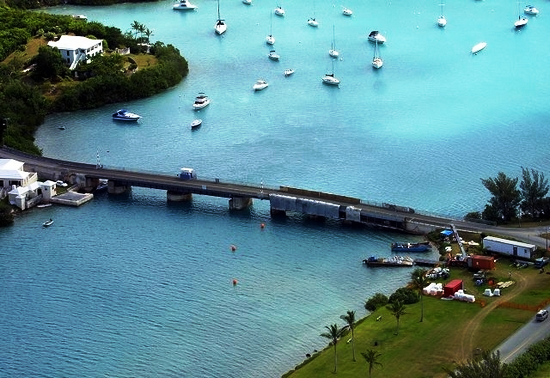
![]()
![]()
![]()
Enter and exit St. George's Island and the town of St. George, via this bridge located in St. David's, north of Kindley Field Road, not far from the airport. It is the bigger of the two swing bridges, so-called because they swing up to allow marine traffic to pass below, about a mile from Longbird Bridge to the west. It is periodically completely or partly closed, including for marine traffic, for construction, resurfacing and repairs. An nice place for taking photographs.
2019. June 19. The Government asked organisations to show how they could help fund the replacement of Longbird Bridge and Swing Bridges according to documents published on its website. A request for information issued through the Ministry of Public Works also appealed for fabricators, project managers and suppliers from around the world to express interest in the projects, as the existing structures in St Georges were both expected to reach the end of their useful lives in 2021. It said detailed designs for the bridges were almost complete and a package of drawings for tenders was scheduled to be published this year. A separate request for proposals invited bids from contractors to demolish and remove Longbird Bridge, which has been closed to traffic for more than a decade. The public RFI for the replacement project was issued on June 7 and an accompanying document, titled Moving Bermuda Forward, explained: The Ministry of Public Works, Government of Bermuda, intends to replace two of their main access bridges. The new bridges will be structural landmarks to be used by locals and visitors for years to come. The ministry is looking to partner with international experts to work on these interesting projects. After the successful completion of an options study and a feasibility study, the design team has now entered into the detailed design phase. This design phase will result in a tender drawing set scheduled to be made public in the third quarter of 2019. The Ministry of Public Works is looking forward to bringing new members to the construction team to finance, fabricate and build these bridges. Interested companies were also told that limited resources meant most construction materials were imported to the island. The document added: The local labour is relatively expensive and specialization in bridge construction and complex infrastructure is limited. Hence, the ministry believes that high-level prefabrication will enable this project to achieve an economical solution and help reduce construction risk. The RFI, which was posted on the procurement notices page of the Governments website, said that the ministry wanted to gather information about the marketplace to help determine future purchasing options or requirements.
It explained that the ministry sought new members to supplement the design team in regard to financing, fabricating and building two new bridges. The document invited expressions of interest from disciplines including general and professional contractors, bridge or steelwork fabricators, financiers, project management, independent checkers, trades and suppliers. It added: This is an opportunity for suppliers to enter into a dialogue with the Ministry of Public Works, present their capabilities/experience, and gain a better understanding of an exciting upcoming opportunity. The ministry intends to use information gathered during this RFI process to guide the procurement strategy for the bridges supply/fabrication/construction. Respondents have until 3pm on August 30 to submit information. It was announced in December 2017 that three UK companies, Ramboll, the lead consultant, as well as Knight Architects and Eadon Consultants, would work together on the bridge replacements. Blueprints for the structures were unveiled last September when it was thought construction on the crossings would begin this summer. It was estimated then that the Longbird Bridge on to St Davids Island from the Causeway and The Main, the largest island in the Bermuda archipelago, would take two years to complete. Construction time for the Swing Bridge from St Davids to St Georges Island was expected to be 30 months. When asked about costs during a public information session when the plans were revealed, in September, Lieutenant-Colonel David Burch, the Minister of Public Works, believed it was too early to provide an estimate He said: Were not prepared to do that until we have the detailed designs for the bridge and know what materials we are going to use. The separate RFP for the demolition of Longbird Bridge was issued on June 10 and has a submission deadline of 3pm on July 19, 2019. It said the public works ministry was inviting tenders from experienced contracting companies for the demolition, removal and safe disposal of the Longbird Bridge superstructure, piers, approach slabs, walls and services.
The present structure was built by the US Army Corps of Engineers and was officially opened in December 1952. When the US Naval Air Station left Bermuda in 1995, they handed over maintenance responsibility to Nasa, who left Bermuda in 1998 and abdicated responsibility. The Government of Bermudas requests for urgent maintenance went unanswered, and the Government assumed responsibility for the bridge, by default ,in December 1998. Rehabilitation works were completed in 2001, but by 2007 the bridge had once again fallen into disrepair. In May 2007, the bridge was closed to marine traffic, and vehicular traffic was reduced to one lane. On July 31, 2007, the bridge was permanently closed, with vehicles diverted to the two newly constructed panel bridges which are still in use today.
2018. September 28. Two new bridges being designed for the East End will be able to withstand Bermudas challenging climate including hurricane conditions and high humidity, designers said.
Longbird Bridge and Swing Bridge computer images supplied
The blueprints for the landmark structures, replacing the Swing Bridge and Longbird Bridge in St Georges, were presented to the public at an information session at Pennos Wharf on Wednesday evening. Steve Thompson, director of major crossings at Ramboll, the lead design consultant on the project, said that the new state-of-the-art Swing Bridge would need to be lowered and locked down during a hurricane, but could remain open for traffic depending on wind speeds. Speaking of the swing section that will lift up every 30 minutes to allow large marine vessels to pass, Mr Thompson told the packed audience: Wind loading is extremely important. We have done initial studies that indicate that the structure is stable during even hurricane winds. We dont have any concerns at the moment but it is something that will be studied in more detail. Both bridges will be built to last avoiding elements such as sharp edges which can easily rust and incorporating curves designed for free flow of water. Ricardo Graham-Ward, bridge engineer for the Ministry of Public Works, added: The new designs also must accommodate for rising storm surge in the future. These two important links to the East End will include adjoining walkways for pedestrians. If enough money is left over at the end of the project, the walkway could be extended to run alongside the Causeway, a feature one member of the audience said locals had wanted for years. Construction on the crossings is expected to begin next summer. It is estimated that the Longbird Bridge will take two years to complete and the Swing Bridge 30 months. Disruption to traffic in both incidences will be minimal during the construction phases. The temporary bridges alongside the Longbird Bridge will be kept open and the old Swing Bridge will remain operational until the new bridge is fully operational. The new bridge will take four minutes to raise and two minutes to lower, the same as the current bridge. Mr Graham-Ward said the Swing Bridge will be operated and maintained locally creating jobs and can function manually when maintenance works are in progress. He said that both bridges will be wider to improve road safety and will have increased clearance for marine vessels. One member of the public asked whether the Longbird Bridge could have extra clearance to allow vessels such as Fisheries and emergency boats to pass under. The presenters said they would look into it. The two structures are designed to mirror each other and take cues from Bermudas natural environment. The Swing Bridge is inspired by the eagle ray while the design of the Longbird Bridge is inspired by a combination of seashells and sea turtles. Mr Graham-Ward said: We want this bridge to be a spectacle, we want this to be an attraction, almost like a destination. Because of the proximity to the airport these are the first two main structures tourists will see and the last thing they see when they leave. It is important to entice them to come back and think not only is Bermudas environment beautiful but so are its landmarks. It is a great opportunity to create an identity. The potential costs of the bridge were not discussed. When asked by The Royal Gazette, Minister of Public Works Lieutenant-Colonel David Burch said he had learnt not to give cost estimates too early in a project. He said: It will come back to haunt you. Were not prepared to do that until we have the detailed designs for the bridge and know what materials we are going to use. At the end of phase three we will have a figure of what it will cost that will be driven, like everything that you build, by when you pull the trigger. If you wait, the number will only go in one direction. Mr Graham-Ward invited school groups get involved in the project. He said: I read in the newspaper that the schools are trying to implement a STEM curriculum. I am sure that this bridge project can be implemented into that curriculum either by hands on approach or by having students come on for site visits during the construction phases. The public were encouraged to offer input or voice concerns about the plans by contacting the Ministry of Public Works.
2018. September 25. New designs for Longbird and Swing Bridges will be unveiled tomorrow. The Ministry of Public Works described the designs as unique landmark structures which will reflect Bermudas welcoming culture. They will on display at an information session at Pennos Wharf, St Georges, from 6pm. British firm Ramboll is being paid $400,000 to design the replacements for the two bridges which are both expected to reach the end of their useful life in 2021. Swing Bridge, linking St Davids to St Georges, was built in the 1960s and has fallen into disrepair in recent years. The bridge no longer opens for passing boats. Longbird Bridge, a 60-metre twin-carriageway bridge at the eastern end of the Causeway, was built in the 1950s. It closed to traffic ten years ago when it was bypassed with twin Bailey bridges.
2017. December 8. British firm Ramboll will be paid $400,000 to design the replacements for Longbird Bridge and Swing Bridge, Lieutenant-Colonel David Burch said today. The public works minister revealed both bridges have a lifespan until 2021, and that he expects Rambolls study to be completed by January so that rebuilding can begin. Colonel Burch also assured MPs that the Causeway is sound, adding: There is no structural or economical argument to support the construction of a new Causeway. Swing Bridge, the gateway to St Georges built in the 1960s, has fallen into disrepair in recent years and no longer opens to shipping. Longbird Bridge, a 60-metre twin carriageway bridge at the east end of the Causeway, was built in the 1950s. It closed to traffic ten years ago, when it was bypassed with twin Bailey Bridge structures. Colonel Burch told the House of Assembly: Over the past decade, there has been an increased awareness of the significance of bridges to our nations economy and the safety of the traveling public. At all levels of government, a concerted effort has been made to reduce the number of structurally deficient bridges that require significant maintenance, rehabilitation, or replacement. Corrosion is a serious threat to the long-term function and integrity of a steel bridge. This is true for all bridges, but it is more serious in Bermuda where salt water and warm weather are the perfect storm to accelerate corrosion on a steel structure. Colonel Burch said the typical lifespan is 50 years for bridges such as Swing and Longbird. He said: Our latest studies on the Swing Bridge show that this bridge will have to be replaced within five years. The work completed earlier this year will allow us to extend its lifespan until 2021, but it is time to rebuild this essential piece of infrastructure. He said of Longbird Bridge: It was condemned several years ago. Two single spans of Bailey bridge were erected to accommodate traffic as a temporary solution. This temporary solution was put in place in 2007. Accelerated corrosion on these bridges forced us to change deck plates earlier this year. In ordinary climate conditions, these plates should last 25 years, but in Bermuda they lasted only ten years. This bridge is safe, but its lifespan is similar to that of the Swing Bridge. He said of the Causeway: Several inspections were performed on the Causeway and various scenarios were also looked at to see what would be the best improvement, for both safety and investment for the taxpayer. The Causeway is an old structure, but I am pleased to advise that the Causeway is sound. Colonel Burch said the design contract was tendered in February this year. He described Ramboll as an award-winning, experienced engineering company which has completed many successful bridge projects around the world. He said with modern technology the target lifespan of the new bridges will be 100 years. Colonel Burch added that Ricardo Graham-Ward, a young Bermudian engineering trainee, will undergo a six-month secondment with Ramboll as part of the contract. He said: This secondment will allow this young Bermudian civil engineer the opportunity to work on this project at the very beginning and be trained by the best moveable bridge engineers in the world. I am certain this attachment will provide him with invaluable training and experience that would otherwise not be available to us.
2017. December 5. Replacements for Swing Bridge and Longbird Bridge (in Hamilton Parish) are in the pipeline after a contract for design work was handed to a British team. Both of the East End structures have suffered major deterioration in recent years, and Swing Bridge was subject to emergency repair work under the One Bermuda Alliance government. A press release from British firm Double Unit announced a contract for full design services has been awarded to lead consultant Ramboll, Knight Architects and Eadon Consulting after an international tender. The two bridges form a critical link in the infrastructure of Bermuda, connecting LF Wade International Airport with Hamilton to the west and the Town of St George to the east. Longbird Bridge was originally constructed in the 1950s as a 60 metres-long twin carriageway steel swing bridge at the east end of the Causeway connecting the island with the airport. However, the bridge closed to traffic ten years ago and was temporarily bypassed with twin Bailey Bridge structures. Swing Bridge spans 120 metres across Ferry Reach, linking St Georges Harbour with the west of the island, and is a critical link for both vehicular and marine traffic. The 1960s swing bridge has received extensive refurbishment and remains open to vehicles but no longer opens to shipping. According to the press release, the design team will undertake studies to determine the most appropriate solutions for the new bridges, including fixed and moveable structures. It added that robustness and durability are key factors as both existing bridges have suffered accelerated deterioration in the tropical climate, which is particularly aggressive to steel structures. In addition, the structures and their mechanisms must be designed to withstand the hurricane-force winds that Bermuda periodically suffers. The design team have collaborated on many bridge projects and between them are responsible for award-winning moveable structures, including the Twin Sails Bridge, Poole (Britain), Gateshead Millennium Bridge (Britain), Lower Hatea Crossing (New Zealand) and Merchant Square Bridge (Britain). Commenting on the appointment, Peter Curran, bridges director at Ramboll, said: We are all delighted to be working on such an exciting project with the Government of Bermuda. We look forward to collaborating to deliver a strong and lasting landmark for the island, one which inspires, connects and can endure the heavy weather conditions that Bermuda has previously suffered. Martin Knight, director at Knight Architects, said: Bermuda is a beautiful and inspiring location for any designer, and it is clear how important these connections are in the everyday life in the island. These bridges are also the entry point for countless tourists every year and they offer an opportunity for gateway structures which reflect the culture and identity of a truly unique place. Work on the project will start immediately.
2017. April 25. Rehabilitation work on the Swing Bridge in St Georges is nearing completion, according to the Ministry of Public Works. The bridge can now safely carry one lane of vehicles with loads of 10 tonnes per axle and a 29-tonne gross vehicle weight, the ministry advised. It is expected to open to two-lane traffic immediately after the contractor removes the remaining scaffolding, which is estimated to take seven days.
2016. August 2. Repairs to the St Georges swing bridge are under way, the Ministry of Public Works has said. Last week, materials for a Bailey bridge which had sat in Kindley Field Park since January gathering rust from the elements and criticism from the Progressive Labour Party was removed in time for Cup Match festivities. A Ministry spokeswoman did not answer a request on what had happened to the Bailey bridge, which had initially been intended to allow vehicles access across Ferry Reach while the damaged swing bridge was fixed. The repair contract is now under way. The Ministry will provide an update in the near future, she said.
2016. June 17. Replacing the crumbling Swing Bridge with a hydraulic counterpart could provide a 50-year fix, Craig Cannonier suggested last night at a town hall meeting in St George. I am very much in favour of a hydraulic bridge, the Minister of Public Works said, citing benefits such as its simple mechanisms and quiet functionality. The Swing Bridge which links St Davids to St Georges has been closed to ships for two years. Motorists can cross it one lane at a time, and a weight limit is in place due to the structures fragile state. Fixing the problem has been estimated at $20 million. The maintenance of the Swing Bridge is going to be astronomical as we move forward. It is an old bridge with old technology, Mr Cannonier said. If we fix the Swing Bridge, well probably have a maximum of 30 years [lifespan]. Id much prefer we get a 50-year span for a few million more dollars and a little more time. In the meantime, Mr Cannonier said that a steelwork contract would be awarded in the next week for a company to strengthen the undercarriage of the Swing Bridge. He estimated that the fortification works would take eight to ten weeks, adding that the weight limit would be lifted once they were finished. To fix the traffic issue, the minister said that he was looking into the possibility of transferring outbound traffic from St Georges via the Severn Bridge at Stokes Point. Another feasibility study involved the removal of one of the Swing Bridges pillars to increase its 63-foot span, allowing larger ships to pass through. Hosted by Quinell Francis, the Mayor of St George, the meeting at Pennos Wharf also featured presentations by Jeff Baron, the Minister of National Security, and Michael Fahy, the Minister of Tourism, Transport and Municipalities.
2016. June 2. The rusted building materials by the St Georges swing bridge are a precautionary measure while strengthening work takes place, the Ministry of Public Works has said. A spokeswoman added that although the Bailey bridge materials were originally intended to relieve the weight restriction on the corroded infrastructure, engineers had since developed a better alternative. Instead, the fortification work will be done from below, helping to reduce traffic build-up and improving emergency vehicle access. This also frees the Bailey bridge to be used for its intended purpose for emergency situations during the hurricane season, she said. The swing bridge which links St Davids to St Georges has been closed since April 2014, allowing motorists across but not opening for ships attempting to pass through. Minister of Public Works Craig Cannonier has described the structure as seriously compromised and promised that the issue has been assigned priority status. Februarys 2016-17 Budget statement revealed that $20 million has been set aside to fix the swing bridge. The spokeswoman added that the construction parts did not rust due to being left outside since January, but that the disassembled Bailey bridge was more than 30 years old, having been acquired from the British Army. Some components now require refurbishment or replacement, she said. Regarding the upcoming strengthening work, the spokeswoman added: A contract for these interim works is expected to be awarded shortly, and will take roughly eight to 12 weeks to perform. Requests for proposal are in development for the replacement of the actual bridge, and a temporary bypass route to allow the work to take place.
2016. May 31. Building materials intended to fix the St Georges swing bridge have rusted after sitting outside for five months, The Royal Gazette has discovered. Dennis Lister, the Shadow Minister of Public Works, called the matter symptomatic of the Governments approach to repairing our infrastructure. In January, a section of Kindley Field Park was set aside as a storage area for a Bailey bridge being constructed for the swing bridge across Ferry Reach, which is badly damaged by rust. But since then the materials have remained seemingly untouched while being exposed to the elements. Mr Lister told this newspaper: One would think that once youve acquired the building materials, the next step is to make the installation and repairs. They were raced down there and now theyre sitting there rusting. If the materials have deteriorated enough that they cant be used, then it will obviously be a waste of money. The bridge which links St Davids to St Georges has been closed since April 2014, allowing motorists across but not opening for ships attempting to pass through. Last December, traffic was reduced to a single lane and a weight limit of ten tonnes was put in place after an engineering survey. The Minister of Public Works, Craig Cannonier, said the bridge had become seriously structurally compromised and that some supports were so corroded they would crumble away when touched. In January, as Bermuda Government engineers awaited structural reports, Mr Cannonier insisted that the bridge was safe for single-lane traffic, despite its rusting traverse beams. He added that the matter was a Government priority and that a Bailey bridge would be erected over the structure while work was carried out. Februarys 2016-17 Budget statement revealed that $20 million was being set aside to restore the bridge. In late March, the Ministry of Public Works performed a structural inspection of the bridge, swinging it open twice for testing purposes. A fortnight later, the Government put out a request for proposal for repairs calling on tenders by April 22 for installation of interim repair measures at the bridge in a Royal Gazette notice. The notice added: The project involves the procurement and fabrication of structural steel elements and their installation to the underside of the Swing Bridge Bridge Deck in St Georges. In mid-April, the plan to erect a Bailey bridge was abandoned in favour of strengthening the bridge from below, with Mr Cannonier citing concerns over traffic build-up and emergency vehicle access. At the time, a spokeswoman for the Ministry of Public Works said work on a full-scale remediation for the bridge had already begun. The Ministry of Public Works did not respond to requests for comment on the issue.
2016. April 15. A plan to erect a Bailey bridge over the St Georges swing bridge has been abandoned in favour of strengthening the bridge from below. A spokeswoman for the Ministry of Public Works said work on a full-scale remediation for the bridge had already begun. We will be concentrating initially on the swing span which is presently the limiting section of the bridge, the spokeswoman said. Solutions have been reviewed and the ministry has prepared a recommendation for cabinet which will be reviewed in due course. The bridge which links St Georges to St Davids was reduced to a single lane of traffic in December after an engineering survey found the bridge was seriously structurally compromised. Craig Cannonier, the Minister of Public Works, announced shortly after that a Bailey bridge would be erected over the structure while work was carried out. However, he said that some concerns were raised about how it would affect traffic in and out of St Georges. This would have required periodic closures of the bridge and, consequently, some level of service disruption to commuters wishing to traverse the bridge, the spokeswoman said. This was understandably of some concern to local St Georges residents, especially with regards to access to emergency services. However, following a detailed inspection and assessment of the bridge, it was determined that it may be possible to strengthen the bridge from underneath without having to close the bridge to traffic. Accordingly, this solution was determined to be the preferable option. While a public meeting was told there was a limit of two months to have a Bailey bridge in place, the spokesman said there are no safety concerns with the bridge with the weight restrictions imposed. The strengthening works will enable us to remove the weight limit and will keep the bridge safe in the medium term while a long-term solution is developed. Had the Bailey bridge approach been appropriate, then we believe that the two-month period would have been reasonable, however we believe that this is a more measured and correct response to the situation. A request for proposal was put out in The Royal Gazette this week, and the ministry expect responses by April 22 and a contract soon after. The weight restriction will be lifted once the works are complete but the single-lane traffic will remain, she said. The start and completion dates for the works will be determined from the bidders responses.
2016. April 12. Government has put out a request for proposal for repairs needed at the St Georges Swing Bridge. In a notice appearing on page 26 of yesterdays edition of The Royal Gazette, the Department of Works and Engineering has called on tenders for installation of interim repair measures at the bridge. The Swing Bridge which links St Davids to St Georges has been closed for two years, allowing motorists access but forcing larger ships to take alternate routes. Last December traffic was reduced to a single lane and had a weight limit put in place after an engineering survey was carried out. Craig Cannonier, the Minister of Public Works, said the bridge had become seriously structurally compromised. A new swing bridge for the site could cost between $10 and $15 million, according to some estimates. The Government notice states: The project involves the procurement and fabrication of structural steel elements and their installation to the underside of the Swing Bridge Deck in St Georges. Full details and tender documents are available at the Ministrys office in the Government Post Office Building on Church Street, with competed tenders due by April 22.
2016. January 27. Government engineers are keeping all options open as they wait for structural reports on the St Georges swing bridge to be completed. Preliminary studies on the bridge have been done and the results are expected to be received by the Ministry of Public Works by the end of next week. Craig Cannonier, the Minister of Public Works, said he had been alarmed by the level of rust on the traverse beams under the bridge. He said fixing the bridge was a Government priority and vowed to ensure that a long-term solution for the bridge would be found as quickly as possible for East End residents. I was alarmed by the state of the bridge, Mr Cannonier said. The rust was falling from the beams into the water. Having said that, the bridge is absolutely safe for single traffic. It is the traverse beams that are rusting. We are taking this extremely seriously and will keep the people of St Georges updated as and when we have more information. Earlier this month a section of Kindley Field Park was set aside as a storage area for a Bailey bridge being constructed for the swing bridge across Ferry Reach. The East End crossing has been reduced to a single lane since December due to serious corrosion, which has also meant vehicles heavier than ten tonnes are off limits. Mr Cannonier said that the department had not ruled out the idea of a completely new bridge. The preliminary studies have been done by contractors and we are waiting for the report in about two weeks, he said. There will be another public meeting shortly afterwards. We want to move towards a long-term solution. I know its inconvenient as I am a resident of St Georges too and I apologize for that. We want to see it swing again and we need it up and running so that we can get the concrete in for the marina project and obviously the new hotel. What exactly it is going to take to make it work again I still dont know, but we are keeping all options open.
2015. December 22. Serious corrosion to the swing bridge across Ferry Reach means that the East Ends crossing will be reduced to a single lane down the middle as of today. Vehicles heavier than ten tonnes could cause the bridge to list, and will thus be off limits. Buses will still be safe to cross, but certain types of fire trucks and construction vehicles will be unable to use the bridge for perhaps two months, until a prefabricated bridge can be laid across it. Last night, angry residents of St Georges told Craig Cannonier, the Minister of Public Works, that the bridge had been allowed to deteriorate after languishing for years. The swing bridge has been a challenge for quite some time now, Mr Cannonier told the town hall meeting at Pennos Wharf. About two years ago, it was decided that we could no longer have the bridge swinging, getting open and then not being able to close. The bridge has remained static since, he said. However, engineers examining the bridge in recent weeks found that it had become seriously structurally compromised, leaving some of its supports so corroded that if you just touch it, its crumbling away. While the steel running north to south on the bridge is intact, the supports going across it from east to west are in really, really bad shape, Mr Cannonier said. The minister told a crowd of about 30 that it was vitally important that the bridge be permanently restored, and said he held out hope for the swing mechanism to be restored. Elizabeth Christopher, a councilor for St Georges, told him that a swing rather than a fixed bridge was imperative for the economic well-being of the Olde Town, but Mr Cannonier said it was impossible to guarantee. Asked to take a guess on how much a new swinging bridge would cost, government engineer Richard Crossley took a guess of $10 to $15 million. Miles Outerbridge, a retired structural engineer, said bridges needed an annual inspection something that had not been carried out on the swing bridge in years. I have seen appalling conditions underneath the bridge for years, Mr Outerbridge said, to applause. That appalling situation didnt happen in the last six months. Its years and years of shameful neglect. I dont know what the mindset of this Government is we dont seem to be able to fix anything. This is not good enough. Mr Cannonier said: I live in St Georges myself. Its a major concern for me to know that we have a bridge in this bad shape. The public would be kept informed with regular town hall meetings as the ministry worked with the Governor to get a replacement bridge put in place with the help of the Royal Engineers. There is a limit of two months to have a Bailey bridge in place: a prefabricated truss bridge that would run over the existing structure, which would do away with the emergency weight restriction. While that bridge was being laid down, St Georges will be completely cut off, but the closure could be as short as 12 hours, Mr Crossley said. After six months at the most, a technical team would be procured to bring back an accurate assessment of the bridge, and a definitive plan for a long-term fix would be done within a year. The news was scant consolation for Jerry Correia, the operator of a charter vessel that once made regular use of the swing bridge. He said he felt upset that everyone has dropped whatever they were doing to save the bridge. Two years ago, in the first month it was closed, I lost $14,000, Mr Correia told the gathering. "Here I am, in debt up to my ears because of that flipping bridge. Mr Correia told The Royal Gazette that his business had just weathered the worst season Ive ever had, with substantial costs piled on to his operations because of detours forced on him by the closure of the swing bridge. Mr Correia also blamed the closure of the swing for accelerating corrosion, because the bridge had formerly oiled its mechanisms by opening and closing. They closed it and left it to corrode, and weve watched it turn into a bucket of rust, he said.
![]()
A Bermuda National Park. A little further west from Achilles Bay, off Coots Pond Road. A favorite public beach, with some unique historic links. See 1775 Bermuda's History 1700-1799. In Philadelphia, the American Continental Congress announced a trade embargo against all colonies remaining loyal to the Crown. When Bermuda tried to bargain with salt, the American colonies refused and requested gunpowder instead. George Washington himself wrote to Bermuda, saying the cause was just for him to obtain the supply. A copy of his letter is still available in Bermuda for interested locals and visitors. A group of Bermudians became sympathetic to the Revolution and on August 14, 1775 stole the island's supply of gunpowder from the British Army's Powder Magazine in St. George's, rolled it down the hill to Tobacco Bay and shipped it to the rebels in America. The embargo was then lifted. The infamous "Gunpowder Plot" created a sensation in Bermuda where those loyal to the Crown were outraged at the treason of certain Bermudians. Ships from Charleston, South Carolina, were waiting under cover of darkness and beyond Bermuda's reefs to carry the gunpowder to Charleston. The event was one of the very first actions by ships that later became among the first ships and actions of the United States Navy. However, the friendliness shown by the USA towards Bermudians did not last forever. British troops were brought in to prevent another such plot.
It is especially popular today with cruise ship visitors. It has some gorgeous views and incredible underwater coral reefs and platforms nearby, which explains its popularity with those who snorkel. There is a moongate (see photo above) facing the beach, also a lovely scenic and walking area behind the bay, which many visitors miss.
In 1918, watched by members of the Bermuda Volunteer Rifle Corps, German prisoners-of-war interned in Bermuda since 1914 left Tobacco Bay in two large lifeboats for a ship moored at Five Fathom Hole which took them to Germany.
Jim & Edna Rhilinger of Plymouth, MA enjoying Tobacco Bay. Photo by the author.
See book: A Time For Treason. Anne Newton Walther. 2000. A novel based on historical fact on the Bermuda Gunpowder Plot. begins in Virginias Tidewater region on the brink of the American Revolution and climaxes on the island of Bermuda a few short months after the battles of Concord and Bunker Hill. From the gentle landscape of the Virginia coast to the final moments of the historically significant event at Bermudas Tobacco Bay, this novel delivers passion, intrigue, and power on a grand scale. 451 pages. $18.75.
![]()
A waterway into the town since 1917. On January 1, 1917, the opening of the new Town Cut Channel St. George's, Bermuda occurred, with the work carried out by Royal Navy dredgers. Governor Sir George Bullock gave a speech in Market Square. The Norwegian cargo ship SS Admiralen, under local pilot James Griffiths, was the first to sail through Town Cut.
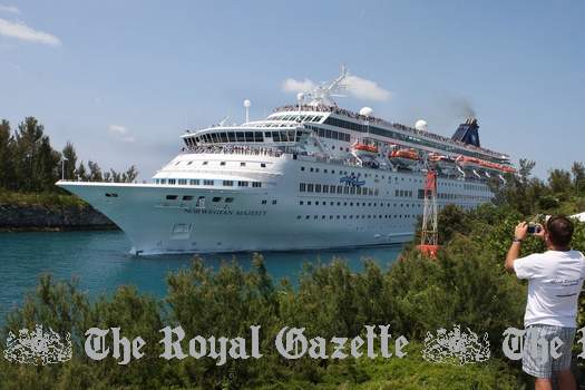
Town Cut, the narrow channel through which cruise ships go to get to the town of St. George when weather permits
Town Cut was the name given to the Royal Navy-constructed narrow natural sea channel between Higgs and Horseshoe Islands and St. George's Island for ships to pass through various islands to get to and from the Town of St. George. Because of the narrowness and geographic location, only ships under a certain size could get through. Geographic location also became significant, due to the fact that high winds passing through the channel can affect shipping. The narrow width of the channel in high winds stops even smaller-size ships from entering, lest they get damaged on the rocks. On good days, only these smaller chips, not the mid-size or larger ones, can access the channel. Unfortunately, the ships that are capable of accessing those ports are generally the cruise lines premium ships that are doing world cruises, not the typical US East Coast to Bermuda cruises. This has meant that most mid size and larger cruise ships have had to anchor at Murray's Anchorage instead of passing through the Cut.
On several occasions until the mid 1950s, Britain's Royal Navy provided the dredgers and the funding to dredge the Cut, but when that service effectively left Bermuda in the 1950s, it became Bermuda's responsibility. In 2011, a Town Cut Channel study was made to dredge the channel to make this more possible. One recommendation is to double its width and remove large parts of three islands. The proposed modification would result in large segments of Higgs, Hen and Horseshoe islands being destroyed. The project is estimated to cost as much as $71 million, and would likely not be completed until 2017. One of Governments top priorities is to try to secure smaller cruise ships capable of docking in St Georges and Hamilton.its)
2017. January 23. The East End celebrated the 100-year anniversary of Town Cut over the weekend an august occasion for St Georges that was marked with a cannon salute and boat parade through the waterway. The sea lane servicing the Olde Towne was first cut through a tiny natural channel between the main island and Higgs Island, which Bermudians commemorated on the first day of 1917 with a procession of ships beginning with the cargo ship SS Admiralen. This weekends anniversary boat parade included the Spirit of Bermuda as well as pilot boats and gigs. It was very successful; we had an overwhelming response, said Rick Spurling, head of the Bermuda Pilot Gig Club, who added that many descendants of legendary pilots and mariners turned out for a gala reception at the East End Mini Yacht Club. The daughter of the pilot Harry Fox, 84-year-old Diddles Fox, went on one of the gigs out to Spit buoy and paraded in, Mr Spurling said. Also on hand were Brinky Tucker and Elaine Fox, the great-grandchildren of pilot James Griffiths who brought the Admiralen through 100 years ago. Town Cut was a substantial addition to the economy of St Georges. Ships were getting bigger, and this allowed freighters and ultimately passenger ships to come through. If we didnt have that channel, we couldnt do anything. But this was also a recognition of the contributions of the pilots to Bermuda over hundreds of years and it continues to this day, Mr Spurling added. Our economy could never have existed without ships being brought safely to port. The cannon was fired from Gates Fort on the shoreline as the vessels came through on Saturday. Town Cut recently split the community down the middle over plans to widen the channel even further, to admit the bigger ships that over the past two decades have been unable to make it through. A lot of people didnt want that to happen because of the exposure we would have to the open ocean, Mr Spurling said. I give full credit to the Government, the Bermuda Tourism Authority and Norwegian Cruise Lines for finding smaller ships that will be coming in to St Georges this year. However, Kenneth Bascome, MP for St Georges North and former mayor of the Olde Towne, said East End residents could yet find a compromise on a larger Town Cut. It was a pleasure to watch, Mr Bascome told The Royal Gazette. It has only put credence to what I proposed all along adding modifications to the Town Cut channel. We dont need massive ships. But I believe something that could carry 1,500 to 2,500 would benefit St Georges, with modifications that would not be devastating to the islands at Town Cut.
2015. November 7. The Bermuda Government is looking into several options to get cruise ships to St Georges without widening Town Cut. Speaking at a town-hall meeting, permanent secretary for the Ministry of Tourism Development and Transport, Francis Richardson, said that finding smaller cruise ships to service the East End is difficult, but the Government is considering alternatives. Next year, in 2016, we will have five visits. And for 2017, so far there are five confirmed, he said. Also in 2017 we are in discussions with NCL to have one of their smaller cruise ships chartered for the entire month of June for the Americas Cup event berthed right here in St Georges. In spite of our best efforts, there are a limited number of cruise ships that can even pull into St Georges. The ministry, with the assistance of the BTA (Bermuda Tourism Authority), continuously encourages our cruise partners to consider St Georges as part of their itinerary plan. Also some which we dont have particularly strong partnerships with. We are encouraging them, but its not easy-going. Because of those challenges, the department has now really started to focus on prioritizing finding a solution for St Georges. We know that Town Cut is certainly an emotive issue for St Georges, and there are proponents and opponents of those options, but there are tangible options that can be utilized in St Georges. We have looked at locations along the north shore of St Georges, close to Murrays Anchorage. There is also another contender towards the eastern side. He added that the ministry is now in advanced discussion about the possible options and he hopes to be able to provide more details and a decision in the future. Asked for more details, he noted a 2008 study that investigated the possibility of erecting a cruise ship pier near Murrays Anchorage, reaching out from the St Georges Golf Course. Members of the public fired a host of questions about the proposals, including asking whether the Government had considered implementing guarantees with the cruise ships in the same way that guarantees are issued for airlines to encourage smaller ships to the Island or if they had looked beyond their usual partners. Mr Richardson responded that staff at the Ministry and BTA have been looking everywhere, leading to the visits scheduled for the next two years. We thought we were very close a few weeks ago to having a ship here for more than ten calls, but it didnt work out, he said. They also asked if tendering passengers from a ship moored outside Town Cut would be feasible, but Mr Richardson said such measures sparked complaints when attempted with the Veendam in 2012. Thats something that still takes place on occasion, but its not an ideal situation and most cruise lines dont like to tender and the East End does present challenges, he said. Sometimes there are challenges getting passengers from the ship to the tender. While one member of the audience called on Government to dredge Town Cut while the dredging equipment is in Bermuda, Mr Richardson said it was not on the cards as there is very little sediment in the cut.
2015. August 20. A new Facebook campaign has been launched dedicated to protecting Town Cut from major modifications. The page, Save St Georges Harbour, was created after it was revealed that fresh studies investigating the possibility of dredging the area had been carried out this summer. As of yesterday afternoon, the page had garnered more than 860 likes with numerous commentators voicing their concerns. A 2011 study highlighted on the campaigns Facebook page investigated what work would be required to allow larger cruise ships to dock in St Georges. That study found that in order to allow tier one, two and three Panamax ships, Town Cut would have to be significantly widened, removing 90 per cent of Higgs, Hen and Horseshoe Islands. In addition to the direct environmental impact, the report warned of increased coastal flooding in the town in the event of an easterly-tracking hurricane. Mayor Quinell Francis and St Georges MP Kenneth Bascome have both voiced support for modifying the cut to some degree. A spokeswoman for the Ministry of Public Works confirmed in July that a fresh study on the channel had been conducted. She stated: There was recently an environmental impact study conducted of the North Shore shipping channel. Since they were here we requested that they also do a study in St Georges as well. The results of this study will assist in determining if we dredge and how much we can dredge the Town Cut.
2015. July 27. A study regarding the possible dredging of Town Cut in St Georges has been carried out, sparking hope that procrastination on the project is finally coming to an end. New mayor Quinell Francis is one of many in recent years who have voiced support for modifying the cut allowing it to accommodate bigger ships to help rejuvenate the Old Town. As the Government of Bermuda confirmed an environmental study has taken place in St Georges Harbour this summer, East End MP Kenneth Bascome, local residents and business owners all said they hoped a resolution on the project would come soon. A spokeswoman for the Ministry of Public Works said: There was recently an environmental impact study conducted of the North Shore shipping channel. Since they were here we requested that they also do a study in St Georges as well. The results of this study will assist in determining if we dredge and how much we can dredge the Town Cut. The topic of modifying Town Cut arose after cruise lines essentially abandoned the port as a destination because larger ships were unable to reach the town. Efforts have been made to attract smaller cruise lines to the port with limited success with only two visits scheduled for this year. However, while some have said larger cruise ships would provide a desperately-needed economic boost, detractors have expressed concern about the potential environmental impact. A government report, released in 2011, found that Town Cut would need to be doubled in size essentially destroying Higgs, Horseshoe and Hen Islands in order to allow Post-Panamax Tier 2 ships to the East End. Less extensive modifications were also considered, such as dredging the channel and a lesser widening of the cut, which would allow safer access for ships such as Holland Americas Veendam. Previous St Georges mayors Garth Rothwell and Mr Bascome had expressed support for some degree of modification of Town Cut. Mr Bascome, now the area MP, said yesterday that he remains supportive of the idea of modifying the cut, provided that studies show it can be done without environmental desecration. I continue to say that once the studies are done the Government needs to decide on a way forward because we have procrastinated too long. We can see that the additional ferry service has been a benefit, but on occasion the ferries have malfunctioned. I believe that with a cruise ship carrying 2,500 passengers, its going to energize the businesses and it would bring people here from other parts of the Island because it would create an ambience.
2011. September. All cruise lines interested in Bermuda and St. George's wanted an update on the Town Cut Channel Study.
2011. September. "Government shouldnt widen Town Cut to bring in tourists who traditionally spend little," insisted local environmental group Greenrock president Judith Landsberg. Dr Landsberg said the Bermuda Government needs to place a greater focus on sustainability, arguing that it has far reaching consequences. Also in September 2011, former St Georges Mayor Henry Hayward called on Government to reconsider a plan to build a pier at Murrays Anchorage rather than blasting Town Cut, as a less expensive alternative. Mr. Hayward said that while the old plan would likely involve the demolition of several buildings and cost the proposed Park Hyatt resort 20 to 30ft of the St. George's Golf Course, a likely conflict. It would also likely require the demolition of several buildings, including a former prison building now used for storage by the Corporation of St Georges, and a derelict theatre. But the pier could allow large ships to service the east end sooner, and at lower cost. The proposed single pier was originally discussed in 2006 as an alternative to widening Town Cut, with passengers possibly being ferried or walking to St Georges. However in March, 2007, Tourism and Transportation Department consultant Larry Jacobs said that the option of developing Murrays Anchorage was not being pursued. Since then, the number of cruise ships visiting the east end has plummeted, with the size of Town Cut limiting the ships capable of visiting the port. Recently, only one ship, the Holland America Lines Veendam, has made regular visits to the east end, tendering at Murrays Anchorage. Mr. Hayward also noted: We used to limit the number of cruise ships in town. Thats the beautiful thing about cruise ships. If the Park Hyatt and a boutique hotel get built and we dont need the cruise ships, we can turn them away. Once we blast Town Cut, its gone forever. A single pier, we can take it down.
![]()
![]()
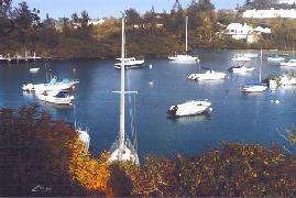 Neither a town
nor a village, a super-exclusive area of Bermuda for rich local
homeowners only. Partly in Hamilton
Parish as well. It
is situated
between the harbors of St. George's and Castle Harbor. It was called Tucker's
Town because it was intended
by a Bermuda Governor by the name of Tucker to be a port to rival St. George's. But it was far more exposed
to the weather and failed to attract many early settlers. So it was never built.
Neither a town
nor a village, a super-exclusive area of Bermuda for rich local
homeowners only. Partly in Hamilton
Parish as well. It
is situated
between the harbors of St. George's and Castle Harbor. It was called Tucker's
Town because it was intended
by a Bermuda Governor by the name of Tucker to be a port to rival St. George's. But it was far more exposed
to the weather and failed to attract many early settlers. So it was never built.
In 1781, 40 acres of cotton were found growing here, which led directly to the British government encouraging the planting of cotton as a commercial crop in 1788. Before the 1920's, it was a quiet, undeveloped and unfashionable area. Residents then, mostly black, sold their land by compulsory purchase order for the creation of the Castle Harbor Hotel and Golf Course, Mid Ocean Club and Golf Course in Tucker's Town for the affluent, while they were relocated elsewhere.
Today, much of the area is the most exclusive and expensive part of Bermuda, so exclusive that casual access is denied to people who do not live in the area, and visitors who do not stay at the Mid Ocean Club. They can go only as far as the Tucker's Town public wharf.
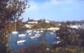 It is a private paradise for the rich and
famous, the area most favored by American,
Canadian and European millionaires. They include the former 3 term Prime
Minister of Italy and a former Mayor of New York City, Michael Bloomberg. Some wealthy
residents so insist on their privacy - like Ross Perot
before his death and his son - worth at least US$ 3.7 billion.
It is a private paradise for the rich and
famous, the area most favored by American,
Canadian and European millionaires. They include the former 3 term Prime
Minister of Italy and a former Mayor of New York City, Michael Bloomberg. Some wealthy
residents so insist on their privacy - like Ross Perot
before his death and his son - worth at least US$ 3.7 billion.
The Bermuda Government allows them to deny others the right to see this beautiful part of Bermuda. They own lavish side by side Bermuda homes here in Tucker's Town. One owned by the late Ross Perot, now his family, is Caliban, which sits on its own 2.86 acres overlooking both Waller's Bay and Surf Bays.
Resplendent homes, all worth over $2 million, are the norm, not the exception, in this loveliest part of southern St. George's Parish. It includes the northern and southern side of the South Road west of the junction with Paynter's Road embracing the easternmost reaches of the Mid Ocean Golf Course and exclusive South Shore with its homes bordering the golf course.
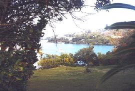 It slices
through the Mid Ocean Golf Course, to the Tucker's Town Public Wharf in one direction and
the Mid Ocean Club in another. If you're not bicycling or on a moped
or on a taxi tour, take the #1 bus, from St. George's or Hamilton, to the Mid Ocean Club.
It is a beautiful ride. Walk to the Tucker's Town Public Wharf, about a half mile away.
Begin your 'tour' here, with a stunning view of Castle Harbor.
It slices
through the Mid Ocean Golf Course, to the Tucker's Town Public Wharf in one direction and
the Mid Ocean Club in another. If you're not bicycling or on a moped
or on a taxi tour, take the #1 bus, from St. George's or Hamilton, to the Mid Ocean Club.
It is a beautiful ride. Walk to the Tucker's Town Public Wharf, about a half mile away.
Begin your 'tour' here, with a stunning view of Castle Harbor.
From here, it's an easy swim diagonally right to the lovely Tucker's Town beach, open to the public via the sea up to the high water mark. En route, you'll see a mysterious canal on the right, quite deep at high tide and sometimes teeming with big fish.
If you're truly adventurous and a good swimmer, or can access a rubber dinghy, motorboat or sailboat, make your way directly or in stages to Castle Island.
Just offshore and west of the island is one of the most outstandingly beautiful places in Bermuda for a deep water swim, or a sail, or a picnic from a boat, or all three, in Castle Harbor.
Photographs by author Keith Archibald Forbes
Natural Arches Beach. South of and below the Mid Ocean Club clubhouse. Off South Road. Bermuda's most famous private beach. See South Shore Park beaches. On September 5, 2003 Hurricane Fabian destroyed the Natural Arches on this beach.
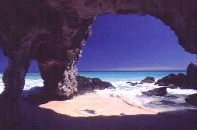
Long before Tucker's Town - and this beach - became fashionable, expensive and not accessible to the average visitor or tourist, it drew many visitors, as a favorite place for an all day outing. Locals referred to it as the "ninth wonder of the world." It was an arrangement of caves and rock exquisitely rendered by Mother Nature. Two caves starting on separate sides of the headland developed backwards until they united. Then the sea broke down and washed out the intervening wall, leaving a tunnel from side to side. Parts of the wall were stacks, needles or rock pillars, standing as isolated columns of stone.
Tuckers Town Graveyard. Before 1920, residents then, mostly black, of the Tuckers Town area, sold their land by compulsory purchase order for the creation of the Castle Harbor Hotel and Golf Course, Mid Ocean Club and Golf Course in Tucker's Town for the affluent, while they were relocated elsewhere. But for many years earlier, their graveyard, located below the Mid Ocean Club, had been used and revered. In 2014 it was partially destroyed, much to the anger of many locals whose grandparents or earlier came from there.
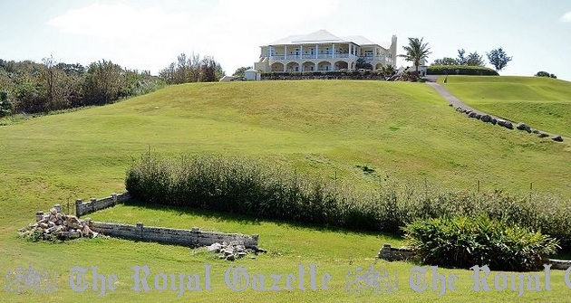
Tucker's Town graveyard
Windsor Beach
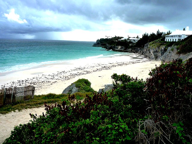
Windsor Beach, exclusively for Tuckers Town residents
![]()
A suburban area which includes pretty Mullet Bay with its own scenic park area just before the entrance to the town of St, George, and the Wellington Cricket Oval, home to the St. George's Cricket Club where annual Cup Matches are often held. Buildings include St. Peter's West. A disused church in St Georges that will soon be home to a new congregation. On August 16, 2018 Gillian Outerbridge, parish administrator at St Peters West, said that building on Wellington Slip Road will now be used by the New Testament Church of God. Ms Outerbridge said: We are delighted that another church will be using the building. The church vestry made the decision to rent out St Peters West instead of selling at this point. The East End church was forced to close last summer due to a shortage of parishioners. The Anglican church was attended by people who lived in the Wellington area but many of the older parishioners have died or become too ill to attend Sunday worship. The Reverend David Raths conducted the last service in June. There were worries that a stained-glass window in the church depicting St Peter, crafted by local artist Vivienne Gardner, could be lost. But Ms Outerbridge said the new tenant meant the safety of the window was assured. She added that a search had started to relocate other items from the church. Ms Outerbridge explained: The new tenants have plans for reconfiguring the interior layout, so have asked us to remove the pews. We hope to find homes for them soon. She said the nine-foot-long pews would make lovely bookshelves or plant stands. The fourteen pews will be sold for $100 each. Anyone interested should contact the church office at 297-2459.
![]()
| City of Hamilton | Hamilton Parish | Paget Parish | Pembroke Parish | Sandys Parish | Smith's Parish |
| Southampton Parish | St. David's Island | St. George's Parish | Town of St. George | Warwick Parish |
![]()
![]()
Banner.jpg)
Authored,
researched, compiled and website-managed by Keith A. Forbes.
Multi-national © 2020. All Rights Reserved